IMAGES TAKEN NEAR TO
Richborough Close, ORPINGTON, BR5 3TQ
Introduction
This page details the photographs taken nearby to Richborough Close, BR5 3TQ by members of the Geograph project.
The Geograph project started in 2005 with the aim of publishing, organising and preserving representative images for every square kilometre of Great Britain, Ireland and the Isle of Man.

There are currently over 7.5m images from over14,400 individuals and you can help contribute to the project by visiting https://www.geograph.org.uk
Image Map
Images are licensed for reuse under creativecommons.org/licenses/by-sa/2.0
Notes
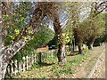
- Clicking on the map will re-center to the selected point.
- The higher the marker number, the further away the image location is from the centre of the postcode.
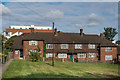
Image Listing (78 Images Found)
Images are licensed for reuse under creativecommons.org/licenses/by-sa/2.0
Image
Details
Distance
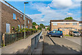
2
Sandway Road alongside Sandway Park
Sandway Park is shown as allotments on the 2017 Ordnance Survey used by Geograph but this is now Sandway Park. Going further back the one inch 7th series OS Maps 1955 - 1961 show a row of houses or flats where the park is now. The park is therefore quite recent. This looks east along Sandway Road with the park on the other side of the fence.
Image: © Marathon
Taken: 9 Sep 2017
0.04 miles
4
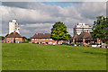
Okemore Gardens
1950s housing around an open green. In the background are the two St Mary Cray tower blocks, Alkham Tower on the left and Horton Tower on the right, both in the process of being demolished.
Image: © Ian Capper
Taken: 19 Jul 2012
0.08 miles
5
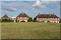
Okemore Gardens
1950s housing around an open green. In the background is part of the 2014 The Ridge development. Compare Image
Image: © Ian Capper
Taken: 29 Jul 2015
0.08 miles
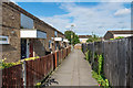
6
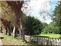
Sandway Park from Sandway Road
Sandway Park is shown as allotments on the 2017 Ordnance Survey used by Geograph but this is now Sandway Park. Going further back the one inch 7th series OS Maps 1955 - 1961 show a row of houses or flats where the park is now. The park is therefore quite recent. This looks west along Sandway Road with the park on the other side of the fence.
Image: © Marathon
Taken: 9 Sep 2017
0.09 miles
7
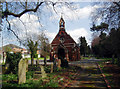
Mortuary chapel, St Mary Cray cemetery
Image: © Dr Neil Clifton
Taken: 18 Apr 2006
0.10 miles
8

St Mary Cray cemetery
The chapel in the cemetery.
Image: © Lindsey Coates
Taken: 6 Apr 2008
0.10 miles
9
Blacksmith's Lane at the junction of Sweeps Lane
Image: © David Howard
Taken: 8 Apr 2012
0.12 miles
10
Withen Close
1950s housing off Okemore Gardens. In the background is part of the 2014 The Ridge development.
Image: © Ian Capper
Taken: 29 Jul 2015
0.13 miles