IMAGES TAKEN NEAR TO
Horsell Road, ORPINGTON, BR5 3BQ
Introduction
This page details the photographs taken nearby to Horsell Road, BR5 3BQ by members of the Geograph project.
The Geograph project started in 2005 with the aim of publishing, organising and preserving representative images for every square kilometre of Great Britain, Ireland and the Isle of Man.

There are currently over 7.5m images from over14,400 individuals and you can help contribute to the project by visiting https://www.geograph.org.uk
Image Map
Images are licensed for reuse under creativecommons.org/licenses/by-sa/2.0
Notes
- Clicking on the map will re-center to the selected point.
- The higher the marker number, the further away the image location is from the centre of the postcode.
Image Listing (19 Images Found)
Images are licensed for reuse under creativecommons.org/licenses/by-sa/2.0
Image
Details
Distance
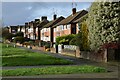
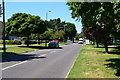
1
Shoreham Road
Looking east from Cotmandene Crescent.
Image: © Trevor Harris
Taken: 14 May 2014
0.15 miles
4
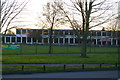
Gray's Farm Primary Academy, Sevenoaks Way, St Paul Cray
Image: © Christopher Hilton
Taken: 1 Mar 2014
0.18 miles
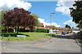
7
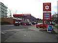
Petrol Station, Chipperfield Road, St Paul's Cray
Image: © Stacey Harris
Taken: 3 Feb 2008
0.20 miles
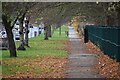
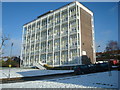
8
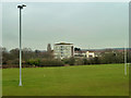
Over the playing fields to Swanscombe House
A prominent block of flats overlooking Chipperfield Road.
Image: © Robin Webster
Taken: 14 Feb 2012
0.20 miles
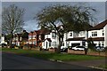
9
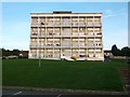
Block of flats on Chipperfield Road, St Paul's Cray
Image: © David Howard
Taken: 25 Oct 2015
0.20 miles