IMAGES TAKEN NEAR TO
Ravenscourt Road, ORPINGTON, BR5 2PP
Introduction
This page details the photographs taken nearby to Ravenscourt Road, BR5 2PP by members of the Geograph project.
The Geograph project started in 2005 with the aim of publishing, organising and preserving representative images for every square kilometre of Great Britain, Ireland and the Isle of Man.

There are currently over 7.5m images from over14,400 individuals and you can help contribute to the project by visiting https://www.geograph.org.uk
Image Map
Images are licensed for reuse under creativecommons.org/licenses/by-sa/2.0
Notes
- Clicking on the map will re-center to the selected point.
- The higher the marker number, the further away the image location is from the centre of the postcode.
Image Listing (55 Images Found)
Images are licensed for reuse under creativecommons.org/licenses/by-sa/2.0
Image
Details
Distance

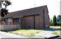
3
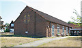
St Barnabas (old church), Rushet Road, St Paul's Cray, Kent
Now a church hall and built 1953
Image: © John Salmon
Taken: 28 Jun 2010
0.06 miles
4
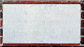
St Barnabas (old church), Rushet Road, St Paul's Cray, Kent - Foundation stone
Image: © John Salmon
Taken: 28 Jun 2010
0.06 miles
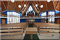
5
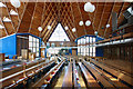
St Barnabas, Rushet Road, St Paul's Cray, Kent - Interior
Image: © John Salmon
Taken: 28 Jun 2010
0.07 miles
6
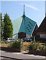
St Barnabas, Rushet Road, St Paul's Cray, Kent
Image: © John Salmon
Taken: 28 Jun 2010
0.07 miles
7
St Barnabas, Rushet Road, St Paul's Cray, Kent - West end
Image: © John Salmon
Taken: 28 Jun 2010
0.07 miles
8
St Barnabas (old church), Rushet Road, St Paul's Cray, Kent
Now a church hall, built 1953
Image: © John Salmon
Taken: 28 Jun 2010
0.08 miles
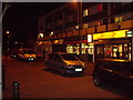
10
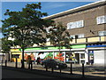
The Co-Operative Supermarket, St Paul's Cray
On Cotmandene Crescent. Part of a row of shops with a block of flats above.
Image: © David Anstiss
Taken: 24 Jul 2011
0.08 miles