IMAGES TAKEN NEAR TO
Leesons Hill, ORPINGTON, BR5 2NH
Introduction
This page details the photographs taken nearby to Leesons Hill, BR5 2NH by members of the Geograph project.
The Geograph project started in 2005 with the aim of publishing, organising and preserving representative images for every square kilometre of Great Britain, Ireland and the Isle of Man.

There are currently over 7.5m images from over14,400 individuals and you can help contribute to the project by visiting https://www.geograph.org.uk
Image Map
Images are licensed for reuse under creativecommons.org/licenses/by-sa/2.0
Notes
- Clicking on the map will re-center to the selected point.
- The higher the marker number, the further away the image location is from the centre of the postcode.
Image Listing (46 Images Found)
Images are licensed for reuse under creativecommons.org/licenses/by-sa/2.0
Image
Details
Distance
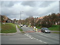
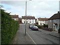
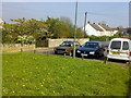
3
Road junction of Leesons Hill, Clarendon Way and Sayes Court Road, St Mary Cray
Leesons Hill heads left towards St Paul's Cray. Clarendon Way leads right to the housing suburbs of St Mary Cray and Sayes Court Road (on the right) leads uphill towards St Mary Cray railway station.
Image: © David Anstiss
Taken: 10 Mar 2013
0.07 miles
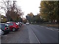
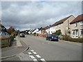
10
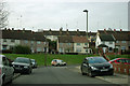
Silverdale Road - awkward TV reception
Although not very far from the very powerful transmitters in the Crystal Palace area, the very high aerials show the road is in the shadow of high ground. Even the higher Ringshall Road beyond has a bit of a problem.
Image: © Robin Webster
Taken: 14 Feb 2012
0.10 miles