IMAGES TAKEN NEAR TO
Englefield Path, ORPINGTON, BR5 2HU
Introduction
This page details the photographs taken nearby to Englefield Path, BR5 2HU by members of the Geograph project.
The Geograph project started in 2005 with the aim of publishing, organising and preserving representative images for every square kilometre of Great Britain, Ireland and the Isle of Man.

There are currently over 7.5m images from over14,400 individuals and you can help contribute to the project by visiting https://www.geograph.org.uk
Image Map
Images are licensed for reuse under creativecommons.org/licenses/by-sa/2.0
Notes
- Clicking on the map will re-center to the selected point.
- The higher the marker number, the further away the image location is from the centre of the postcode.
Image Listing (58 Images Found)
Images are licensed for reuse under creativecommons.org/licenses/by-sa/2.0
Image
Details
Distance
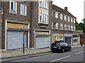
2
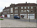
Tillingbourne Green shops, Poverest
A weekday lunchtime - but only the convenience shop is open.
Image: © Ian Capper
Taken: 29 May 2008
0.06 miles
3
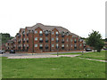
Seven Stiles Court
"Affordable housing" development on Tillingbourne Green.
Image: © Ian Capper
Taken: 29 May 2008
0.06 miles
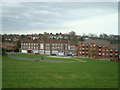
4
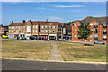
Tillingbourne Green
Late 1940s parade of shops and recent apartment block in Tillingbourne Green (the latter called Seven Stiles Court, named after a pub, the Seven Stiles, previously on the site but which was demolished in 2004) either side of its junction with Ranmore Path.
Image: © Ian Capper
Taken: 14 Sep 2016
0.06 miles
5
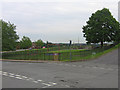
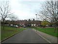
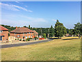
Tillingbourne Green Recreation Ground, Poverest
At the junction between Tillingbourne Green (to the right) and Church Hill Wood (running left to right).
Image: © Ian Capper
Taken: 29 May 2008
0.07 miles
6
Ranmore Path shops, Poverest
A weekday lunchtime, but all the shops are closed.
Image: © Ian Capper
Taken: 29 May 2008
0.07 miles
8
Sherborne Road, Poverest
Running down to its junction with Church Hill Wood, with Tillingbourne Green the other side of the junction, leading to the Poverest Centre and Poverest Primary School.
Image: © Ian Capper
Taken: 29 May 2008
0.07 miles
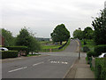
10
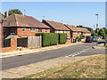
Englefield Crescent
Late 1940s housing at the western end of Tillingbourne Green. Prior to development, old maps show this area, including the open land, to have been woodland.
Image: © Ian Capper
Taken: 14 Sep 2016
0.10 miles