IMAGES TAKEN NEAR TO
Tillingbourne Green, ORPINGTON, BR5 2EX
Introduction
This page details the photographs taken nearby to Tillingbourne Green, BR5 2EX by members of the Geograph project.
The Geograph project started in 2005 with the aim of publishing, organising and preserving representative images for every square kilometre of Great Britain, Ireland and the Isle of Man.

There are currently over 7.5m images from over14,400 individuals and you can help contribute to the project by visiting https://www.geograph.org.uk
Image Map
Images are licensed for reuse under creativecommons.org/licenses/by-sa/2.0
Notes
- Clicking on the map will re-center to the selected point.
- The higher the marker number, the further away the image location is from the centre of the postcode.
Image Listing (81 Images Found)
Images are licensed for reuse under creativecommons.org/licenses/by-sa/2.0
Image
Details
Distance
1
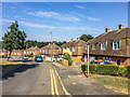
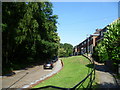
Tillingbourne Green
The eastern side of Tillingbourne Green, with a standard late 1940s design for the immediate area of Threntham Drive and Cray Valley Road as well as here, dating from the late 1940s or early 1950s.
Image: © Ian Capper
Taken: 14 Sep 2016
0.02 miles
2
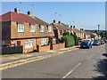
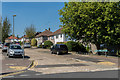
Trentham Drive
A standard design for the immediate area of Threntham Drive, Tillingbourne Green and Cray Valley Road dating from the late 1940s or early 1950s.
Image: © Ian Capper
Taken: 14 Sep 2016
0.06 miles
3
Five dogs, four humans
On Amherst Drive.
Image: © Robin Webster
Taken: 14 Feb 2012
0.08 miles
4
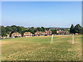
Tillingbourne Green
Looking across to the eastern side of Tillingbourne Green, with a standard housing design for the immediate area of Threntham Drive and Cray Valley Road as well as here, dating from the late 1940s or early 1950s.
Prior to development, old maps show this area, including the open land, to have been woodland.
Image: © Ian Capper
Taken: 14 Sep 2016
0.08 miles
5
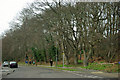
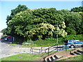
Amherst Wood, St Mary Cray
Seen from Amherst Close, Amherst Wood is a small woodland located between Amherst Drive, Amherst Close and the railway line, just west of St Mary Cray station.
Image: © Marathon
Taken: 27 Jun 2011
0.09 miles
6
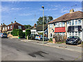
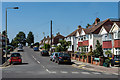
Priorsford Avenue
Cul-de-sac off Sidmouth Road, development of which maps suggest had started by the late 1930s.
Image: © Ian Capper
Taken: 17 Aug 2016
0.09 miles
7
Amherst Wood, St Mary Cray
Seen from the junction of Amherst Close and Amherst Drive, Amherst Wood is a small woodland located between these two roads and the railway line, just west of St Mary Cray station.
Image: © Marathon
Taken: 27 Jun 2011
0.09 miles
8
Trentham Drive
A couple of pre-War houses with a standard design for the immediate area of Threntham Drive, Tillingbourne Green and Cray Valley Road dating from the late 1940s or early 1950s beyond.
Image: © Ian Capper
Taken: 14 Sep 2016
0.10 miles
9
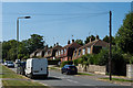
Cray Valley Road
Road built partly in the late 1930s and partly in the late 1940s/early 1950s connecting Cray Avenue and Poverest Road. This is the later section, with a distinctive standard design of housing used in parts of this road, Threntham Drive and Tillingbourne Green.
Image: © Ian Capper
Taken: 17 Aug 2016
0.10 miles
10
Trentham Drive
Three pre-War houses on the right with a standard design for the immediate area of Threntham Drive, Tillingbourne Green and Cray Valley Road dating from the late 1940s or early 1950s beyond.
Image: © Ian Capper
Taken: 17 Aug 2016
0.10 miles