IMAGES TAKEN NEAR TO
Kingsway, ORPINGTON, BR5 1PR
Introduction
This page details the photographs taken nearby to Kingsway, BR5 1PR by members of the Geograph project.
The Geograph project started in 2005 with the aim of publishing, organising and preserving representative images for every square kilometre of Great Britain, Ireland and the Isle of Man.

There are currently over 7.5m images from over14,400 individuals and you can help contribute to the project by visiting https://www.geograph.org.uk
Image Map
Images are licensed for reuse under creativecommons.org/licenses/by-sa/2.0
Notes
- Clicking on the map will re-center to the selected point.
- The higher the marker number, the further away the image location is from the centre of the postcode.
Image Listing (54 Images Found)
Images are licensed for reuse under creativecommons.org/licenses/by-sa/2.0
Image
Details
Distance
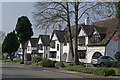
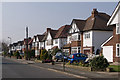
1
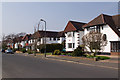
Kingsway
Part of the 1930s development of Petts Wood.
Image: © Ian Capper
Taken: 25 Mar 2011
0.04 miles
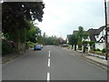
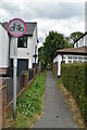
2
Kingsway
One of a number of roads in Petts Wood built by the master builder Noel Rees in the 1930s. Wood Ride is beyond on the left.
Image: © Ian Capper
Taken: 25 Mar 2011
0.06 miles
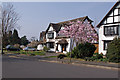
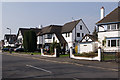
3
Wood Ride
One of a number of roads in Petts Wood built by the master builder Noel Rees in the 1930s, with the rounded doorways and whitewashed walls being typical of his work.
Image: © Ian Capper
Taken: 25 Mar 2011
0.07 miles
5
Wood Ride
One of a number of roads in Petts Wood built by the master builder Noel Rees in the 1930s, with the rounded doorways and whitewashed walls being typical of his work.
Image: © Ian Capper
Taken: 25 Mar 2011
0.09 miles
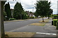
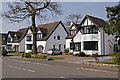
8
Kingsway
One of a number of roads in Petts Wood built by the master builder Noel Rees in the 1930s.
Image: © Ian Capper
Taken: 25 Mar 2011
0.10 miles
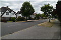
10
Kingsway
Part of the 1930s development of Petts Wood. Compare the style of housing with that at the eastern end of the road (see Image).
Image: © Ian Capper
Taken: 25 Mar 2011
0.11 miles