IMAGES TAKEN NEAR TO
Broadcroft Road, ORPINGTON, BR5 1ET
Introduction
This page details the photographs taken nearby to Broadcroft Road, BR5 1ET by members of the Geograph project.
The Geograph project started in 2005 with the aim of publishing, organising and preserving representative images for every square kilometre of Great Britain, Ireland and the Isle of Man.

There are currently over 7.5m images from over14,400 individuals and you can help contribute to the project by visiting https://www.geograph.org.uk
Image Map
Images are licensed for reuse under creativecommons.org/licenses/by-sa/2.0
Notes
- Clicking on the map will re-center to the selected point.
- The higher the marker number, the further away the image location is from the centre of the postcode.
Image Listing (84 Images Found)
Images are licensed for reuse under creativecommons.org/licenses/by-sa/2.0
Image
Details
Distance
3
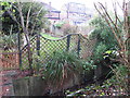
Footbridge over the Kyd Brook - East Branch, west of Broadcroft Road, BR5
Image: © Mike Quinn
Taken: 18 Nov 2010
0.10 miles
4
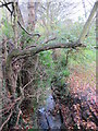
The Kyd Brook - East Branch, west of Broadcroft Road, BR5
Image: © Mike Quinn
Taken: 18 Nov 2010
0.10 miles
5
The Kyd Brook - East Branch, west of Heath Side, BR5
Image: © Mike Quinn
Taken: 18 Nov 2010
0.10 miles
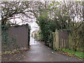
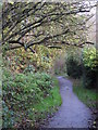
6

Footpath west of Broadcroft Road, BR5 (2)
Image: © Mike Quinn
Taken: 18 Nov 2010
0.10 miles
7
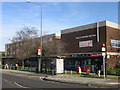
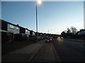
Shopping Parade, Crofton
A rather run down shopping parade in Crofton Lane, backing onto the Place Farm Estate
Image: © Ian Capper
Taken: 22 Jan 2008
0.11 miles
10
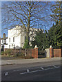
Crofton Court
When Crofton Lane was a genuine country lane, Crofton Court, built in the early 19th century was about the only development in it. It now stands out as the only building of interest in an area largely developed post war, including a number of 1970s high density estates, such as the Place Farm Estate (see Image).
It is grade II listed - for listing particulars see www.historicengland.org.uk/listing/the-list/list-entry/1359351.
Image: © Ian Capper
Taken: 22 Jan 2008
0.11 miles