IMAGES TAKEN NEAR TO
Chatsworth Parade, ORPINGTON, BR5 1DE
Introduction
This page details the photographs taken nearby to Chatsworth Parade, BR5 1DE by members of the Geograph project.
The Geograph project started in 2005 with the aim of publishing, organising and preserving representative images for every square kilometre of Great Britain, Ireland and the Isle of Man.

There are currently over 7.5m images from over14,400 individuals and you can help contribute to the project by visiting https://www.geograph.org.uk
Image Map
Images are licensed for reuse under creativecommons.org/licenses/by-sa/2.0
Notes
- Clicking on the map will re-center to the selected point.
- The higher the marker number, the further away the image location is from the centre of the postcode.
Image Listing (144 Images Found)
Images are licensed for reuse under creativecommons.org/licenses/by-sa/2.0
Image
Details
Distance
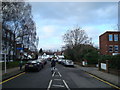
1
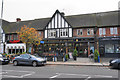
Alley to footbridge over railway, Petts Wood
Featuring a blackboard for Petts Wood Cafe 'over the bridge', which is round to the left.
Image: © Robin Webster
Taken: 4 Feb 2012
0.02 miles
2
The Pet Shop of Petts Wood
An inevitable pun?
Image: © Ian Capper
Taken: 5 Jan 2009
0.02 miles
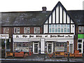
5
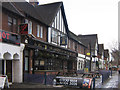
The Sovereign of the Seas
The name of this pub derives from an historic link with the Petts Family, after which Petts Wood (the original woodland, from which the name of the 1930s residential development was in turn derived). The Petts family were leading shipbuilders from the 15th to 17th centuries, and the Sovereign of the Seas, designed in 1634 by Phineas Pett for Charles I and entering service in 1638, was the most magnificent ship of the 17th century. She was renamed the Royal Sovereign on the accession of Charles II.
The pub, operated by Wetherspoons, was opened on 1 March 1995, ending the 60 year monopoly of the Daylight Inn (see Image) as the only pub in Petts Wood.
Image: © Ian Capper
Taken: 5 Jan 2009
0.03 miles
7
The Sovereign of the Seas
The local Wetherspoon's, centrally placed in the main shopping street.
Image: © Bill Boaden
Taken: 10 Oct 2015
0.03 miles
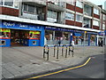
8
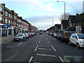
Chatsworth Parade
In Queensway, the shopping street of Petts Wood West, built in 1933 alongside and parallel with the railway, with this 1960s extension extending the parade northwards. In the parade can be seen Woolworths, which had closed two days previously (see Image).
Image: © Ian Capper
Taken: 5 Jan 2009
0.04 miles
9
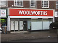
Woolworths, Petts Wood
Woolworths in Petts Wood closed on Saturday 3 January 2009, two days before this photo was taken.
Image: © Ian Capper
Taken: 5 Jan 2009
0.04 miles
10
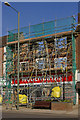
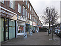
Former Woolworths, Petts Wood
This is the former Woolworths, in Queensway, Petts Wood (see Image).
It has now been totally gutted, with only the facade remaining, and is due to be rebuilt with a replacement shop on the ground floor and offices above.
On the right hand side of the photo can be seen the Petts Wood village sign - see Image
Image: © Ian Capper
Taken: 5 Mar 2010
0.04 miles