IMAGES TAKEN NEAR TO
Frankswood Avenue, ORPINGTON, BR5 1BP
Introduction
This page details the photographs taken nearby to Frankswood Avenue, BR5 1BP by members of the Geograph project.
The Geograph project started in 2005 with the aim of publishing, organising and preserving representative images for every square kilometre of Great Britain, Ireland and the Isle of Man.

There are currently over 7.5m images from over14,400 individuals and you can help contribute to the project by visiting https://www.geograph.org.uk
Image Map
Images are licensed for reuse under creativecommons.org/licenses/by-sa/2.0
Notes
- Clicking on the map will re-center to the selected point.
- The higher the marker number, the further away the image location is from the centre of the postcode.
Image Listing (143 Images Found)
Images are licensed for reuse under creativecommons.org/licenses/by-sa/2.0
Image
Details
Distance
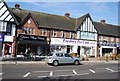
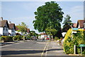
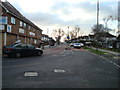
1
Crest View Drive
A suburban road in Petts Wood.
Image: © Bill Boaden
Taken: 10 Oct 2015
0.07 miles
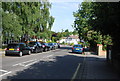
3
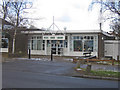
Petts Wood Library
Built in 1961 and extended in 1968.
Image: © Ian Capper
Taken: 5 Jan 2009
0.08 miles
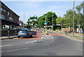
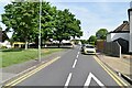
7
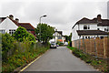
The end of Tent Peg Lane
Getting back into suburbia from Jubilee Country Park.
Image: © Bill Boaden
Taken: 10 Oct 2015
0.10 miles