IMAGES TAKEN NEAR TO
Deer Park Way, WEST WICKHAM, BR4 9QQ
Introduction
This page details the photographs taken nearby to Deer Park Way, BR4 9QQ by members of the Geograph project.
The Geograph project started in 2005 with the aim of publishing, organising and preserving representative images for every square kilometre of Great Britain, Ireland and the Isle of Man.

There are currently over 7.5m images from over14,400 individuals and you can help contribute to the project by visiting https://www.geograph.org.uk
Image Map
Images are licensed for reuse under creativecommons.org/licenses/by-sa/2.0
Notes
- Clicking on the map will re-center to the selected point.
- The higher the marker number, the further away the image location is from the centre of the postcode.
Image Listing (41 Images Found)
Images are licensed for reuse under creativecommons.org/licenses/by-sa/2.0
Image
Details
Distance
1
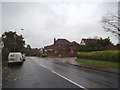
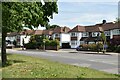
Deer Park Way
The view from Tiepigs Lane in West Wickham.
Image: © Gordon Griffiths
Taken: 14 Nov 2015
0.02 miles
2
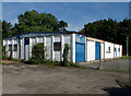
Greenacres 3rd West Wickham Scout Group BR4
Next to Coney Hall FC pavilion, Tiepigs Lane.
Image: © Philip Talmage
Taken: 23 Aug 2005
0.04 miles
6
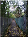
Footpath alongside railway line
This footpath leads away from Tiepigs Lane with the railway embankment on the right. The Hayes branch line from the Mid-Kent line at Elmers End was built by the West Wickham & Hayes Railway, but was sold to the South Eastern Railway on the opening day, 29th May 1882. This area saw urbanisation relatively late and usage of the line remained low until electrification in 1925.
Image: © Marathon
Taken: 21 Oct 2012
0.08 miles
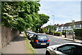
7
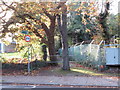
Public footpath near Hayes
A public footpath in the outer suburbs of south east London. To the right of the path is a railway embankment.
Image: © Malc McDonald
Taken: 27 Oct 2019
0.08 miles
8
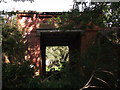
Another arch of Trepigs Lane railway Bridge
As seen from a footpath from Trepigs Lane to Pickhurst Rise.
This arch is about 40 yards left of Image
Image: © David Anstiss
Taken: 28 Aug 2011
0.09 miles
9
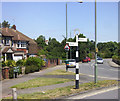
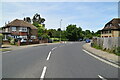
Old Style Signpost
At the junction of Addington Road and Tiepigs Lane (great name)
The loop at the top reminds me of our local signposts in Oxfordshire. This one is inscribed "The London Borough of Bromley"
Image: © Des Blenkinsopp
Taken: 30 Jun 2014
0.09 miles
10
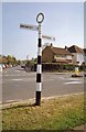
Old Direction Sign - Signpost by Addington Road, West Wickham
Annulus finial - 2 arms; Bromley parish halo by the UC road, in parish of Bromley (Bromley District), West Wickham.
Surveyed
Milestone Society National ID: KE_TQ3965
Image: © Milestone Society
Taken: Unknown
0.09 miles