IMAGES TAKEN NEAR TO
Bencurtis Park, WEST WICKHAM, BR4 9QG
Introduction
This page details the photographs taken nearby to Bencurtis Park, BR4 9QG by members of the Geograph project.
The Geograph project started in 2005 with the aim of publishing, organising and preserving representative images for every square kilometre of Great Britain, Ireland and the Isle of Man.

There are currently over 7.5m images from over14,400 individuals and you can help contribute to the project by visiting https://www.geograph.org.uk
Image Map
Images are licensed for reuse under creativecommons.org/licenses/by-sa/2.0
Notes
- Clicking on the map will re-center to the selected point.
- The higher the marker number, the further away the image location is from the centre of the postcode.
Image Listing (36 Images Found)
Images are licensed for reuse under creativecommons.org/licenses/by-sa/2.0
Image
Details
Distance
8
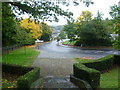
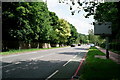
Corkscrew Hill from the steps of the West Wickham War Memorial
This was a rather damp and miserable Sunday afternoon. Corkscrew Hill is rather a nice name but something of an exaggeration when considering switchback roads in upland areas.
Image: © Marathon
Taken: 21 Oct 2012
0.17 miles
9
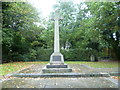
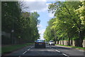
West Wickham War Memorial
West Wickham War Memorial is next to a bend in Corkscrew Hill. For the view in the other direction see http://www.geograph.org.uk/photo/3188697
Image: © Marathon
Taken: 21 Oct 2012
0.17 miles
