IMAGES TAKEN NEAR TO
Bramley Way, WEST WICKHAM, BR4 9NT
Introduction
This page details the photographs taken nearby to Bramley Way, BR4 9NT by members of the Geograph project.
The Geograph project started in 2005 with the aim of publishing, organising and preserving representative images for every square kilometre of Great Britain, Ireland and the Isle of Man.

There are currently over 7.5m images from over14,400 individuals and you can help contribute to the project by visiting https://www.geograph.org.uk
Image Map
Images are licensed for reuse under creativecommons.org/licenses/by-sa/2.0
Notes
- Clicking on the map will re-center to the selected point.
- The higher the marker number, the further away the image location is from the centre of the postcode.
Image Listing (25 Images Found)
Images are licensed for reuse under creativecommons.org/licenses/by-sa/2.0
Image
Details
Distance
5
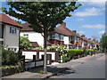
Copse Avenue, BR4 (2)
Shows the location of the entrance to the Image
Image: © Mike Quinn
Taken: 16 Jun 2010
0.08 miles
6
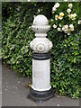
Bollard at the alleyway between Copse Avenue, BR4 and Links View Road, CR0
The location of this bollard is shown in Image
Image: © Mike Quinn
Taken: 16 Jun 2010
0.09 miles

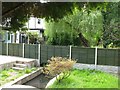
9
Alleyway between Copse Avenue, BR4 and Links View Road, CR0
Shows the location of Image
Image: © Mike Quinn
Taken: 16 Jun 2010
0.10 miles
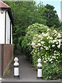
10
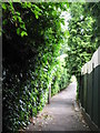
Alleyway between Links View Road, CR0 and Copse Avenue, BR4
The Beck passes under the path by the first tree on the right.
Image: © Mike Quinn
Taken: 16 Jun 2010
0.11 miles