IMAGES TAKEN NEAR TO
Cheyne Park Drive, WEST WICKHAM, BR4 9LQ
Introduction
This page details the photographs taken nearby to Cheyne Park Drive, BR4 9LQ by members of the Geograph project.
The Geograph project started in 2005 with the aim of publishing, organising and preserving representative images for every square kilometre of Great Britain, Ireland and the Isle of Man.

There are currently over 7.5m images from over14,400 individuals and you can help contribute to the project by visiting https://www.geograph.org.uk
Image Map
Images are licensed for reuse under creativecommons.org/licenses/by-sa/2.0
Notes
- Clicking on the map will re-center to the selected point.
- The higher the marker number, the further away the image location is from the centre of the postcode.
Image Listing (13 Images Found)
Images are licensed for reuse under creativecommons.org/licenses/by-sa/2.0
Image
Details
Distance
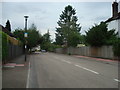
1
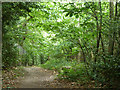
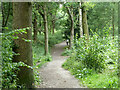
Path, Spring Park woodland
A path into the wood from Woodland Way.
Image: © Robin Webster
Taken: 1 Jul 2011
0.09 miles
2
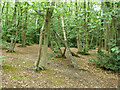
Private woodland, Spring Park
Part of the woodland fenced off and used by the scout and guide movement.
Image: © Robin Webster
Taken: 1 Jul 2011
0.10 miles
3
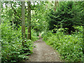
Path in Spring Park woodland
Public open space.
Image: © Robin Webster
Taken: 1 Jul 2011
0.15 miles
4
Spring Park
Spring Park was bought by the City of London Corporation in 1926 and is managed by them as a wildlife reserve. http://www.cityoflondon.gov.uk/things-to-do/green-spaces/city-commons/spring-park/Pages/default.aspx
Image: © Glyn Baker
Taken: 31 Aug 2016
0.16 miles
6
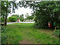
A way out of Spring Park woods
This emerges at the junction of Woodland Way and The Grove.
Image: © Robin Webster
Taken: 1 Jul 2011
0.22 miles
7
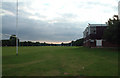
Sparrows Den - Beccehamian RFC
Beccehamian Rugby Football Club was formed in 1933 as Old Beccehamian RFC by former pupils of Beckenham County School for Boys. Now an open club but still drawing many new members from Langley Park School, the club has three full-size pitches at Sparrow's Den, and features ladies and mini-rugby as well as senior men's teams.
Image: © Philip Talmage
Taken: 20 Aug 2005
0.23 miles
8
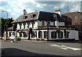
The Swan Inn, West Wickham BR4
In front of the 18th century Swan Inn there stood, until 1935, a great elm called the "Stocks Tree", marking the centre of the old village of West Wickham - at the point once known as Norwood Cross. The High Street extends to the left, in the photo, while in Station Road, just to the right of the Swan, stands the Post Office.
Image: © Philip Talmage
Taken: 7 Aug 2005
0.23 miles
10
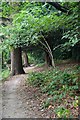
Public footpath in Spring Park woods
This is used by the London Loop long distance path.
Image: © Robin Webster
Taken: 1 Jul 2011
0.24 miles