IMAGES TAKEN NEAR TO
The Grove, WEST WICKHAM, BR4 9LA
Introduction
This page details the photographs taken nearby to The Grove, BR4 9LA by members of the Geograph project.
The Geograph project started in 2005 with the aim of publishing, organising and preserving representative images for every square kilometre of Great Britain, Ireland and the Isle of Man.

There are currently over 7.5m images from over14,400 individuals and you can help contribute to the project by visiting https://www.geograph.org.uk
Image Map
Images are licensed for reuse under creativecommons.org/licenses/by-sa/2.0
Notes
- Clicking on the map will re-center to the selected point.
- The higher the marker number, the further away the image location is from the centre of the postcode.
Image Listing (31 Images Found)
Images are licensed for reuse under creativecommons.org/licenses/by-sa/2.0
Image
Details
Distance
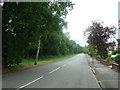
2
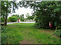
A way out of Spring Park woods
This emerges at the junction of Woodland Way and The Grove.
Image: © Robin Webster
Taken: 1 Jul 2011
0.14 miles
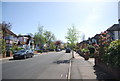
4
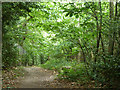
Path, Spring Park woodland
A path into the wood from Woodland Way.
Image: © Robin Webster
Taken: 1 Jul 2011
0.15 miles
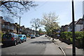
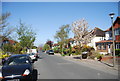
5
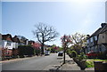
Copse Avenue
Heading uphill to Spring Bank.
Image: © N Chadwick
Taken: 9 Apr 2011
0.16 miles