IMAGES TAKEN NEAR TO
The Grove, WEST WICKHAM, BR4 9JS
Introduction
This page details the photographs taken nearby to The Grove, BR4 9JS by members of the Geograph project.
The Geograph project started in 2005 with the aim of publishing, organising and preserving representative images for every square kilometre of Great Britain, Ireland and the Isle of Man.

There are currently over 7.5m images from over14,400 individuals and you can help contribute to the project by visiting https://www.geograph.org.uk
Image Map
Images are licensed for reuse under creativecommons.org/licenses/by-sa/2.0
Notes
- Clicking on the map will re-center to the selected point.
- The higher the marker number, the further away the image location is from the centre of the postcode.
Image Listing (43 Images Found)
Images are licensed for reuse under creativecommons.org/licenses/by-sa/2.0
Image
Details
Distance
1
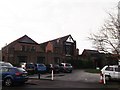
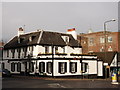
Emmanuel United Reformed Church, West Wickham
On the junction of The Grove and Park Avenue (on the left).
Image: © David Anstiss
Taken: 18 Dec 2011
0.05 miles
2
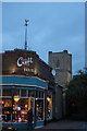
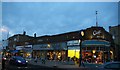
Croft Radio, West Wickham
The end of a run of interwar shops on West Wickham's main shopping street. Croft Radio is apparently no more but the sign gives it that little extra interwar feeling.
In the background, the church of St Francis of Assisi.
Image: © Christopher Hilton
Taken: 30 Nov 2012
0.12 miles
4
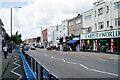
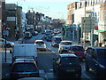
West Wickham
High Street, with the Covid-19 enlarged pavements to assist social distancing.
Image: © Peter Trimming
Taken: 20 Jun 2020
0.12 miles
5
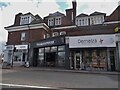
The Croft, West Wickham
A run of inter-war shops on West Wickham's main shopping street. In the background, the church of St Francis of Assisi.
Image: © Christopher Hilton
Taken: 30 Nov 2012
0.12 miles
7
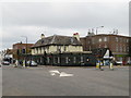
The Swan pub, West Wickham
The Swan pub in the centre of West Wickham, a suburb of south east London.
Image: © Malc McDonald
Taken: 20 Oct 2019
0.14 miles
8
The Swan Public house, West Wickham
A Grade II listed building on the junction of West Wickham High Street (on the left) and Station Road (on the right).
See http://www.britishlistedbuildings.co.uk/en-358493-the-swan-public-house-bromley for more details about the building.
Image: © David Anstiss
Taken: 18 Dec 2011
0.14 miles
9
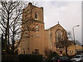
St Francis church: bell tower
The tower contains 8 bells which are rung as a carillon (hammers operated by a keyboard), not by the traditional method of full-circle ringing with ropes.
Image: © Stephen Craven
Taken: 5 Aug 2014
0.14 miles
10
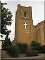
St Francis of Assisi Church, West Wickham
On Ravenswood Avenue.
Image: © David Anstiss
Taken: 18 Dec 2011
0.14 miles