IMAGES TAKEN NEAR TO
Princes Way, WEST WICKHAM, BR4 9HS
Introduction
This page details the photographs taken nearby to Princes Way, BR4 9HS by members of the Geograph project.
The Geograph project started in 2005 with the aim of publishing, organising and preserving representative images for every square kilometre of Great Britain, Ireland and the Isle of Man.

There are currently over 7.5m images from over14,400 individuals and you can help contribute to the project by visiting https://www.geograph.org.uk
Image Map
Images are licensed for reuse under creativecommons.org/licenses/by-sa/2.0
Notes
- Clicking on the map will re-center to the selected point.
- The higher the marker number, the further away the image location is from the centre of the postcode.
Image Listing (44 Images Found)
Images are licensed for reuse under creativecommons.org/licenses/by-sa/2.0
Image
Details
Distance
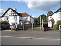
2
Kingsway, Coney Hall
Although it now seems the quintessence of suburbia, in the 1930s this street was at the centre of a rent- and mortgage-strike led by the local woman (and Communist Party member) Elsy Borders, as a protest against shoddy building standards in the then newly-erected estate and the way that building societies had been in cahoots with speculative builders to get buyers into these substandard houses. http://www.grahamstevenson.me.uk/index.php?option=com_content&view=article&id=1189:-borders-elsy-and-jim&catid=2:b&Itemid=98 Clearly the fact they are still here indicates that a lot of remedial work has happened since.
Image: © Christopher Hilton
Taken: 17 Jun 2012
0.04 miles
3
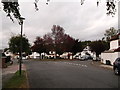
Birch Tree Avenue meets Queensway, Coney Hall
The road from Layhams Road, meets a road heading left to Church Drive.
The junction is marked by the red leafed cherry trees.
Image: © David Anstiss
Taken: 9 Oct 2011
0.09 miles
4
Path onto West Wickham Common, near Hayes
A path leading onto West Wickham Common, in the outer suburbs of south east London.
Image: © Malc McDonald
Taken: 27 Oct 2019
0.12 miles
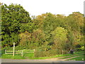
5
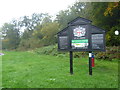
West Wickham Common
This is the view from Gates Green Road which runs along the western edge of West Wickham Common. The Common is mostly wooded and forms a continuous tract of open land with Hayes Common and the London Green Belt. West Wickham Common is noted for its wonderful ancient oak pollards. As can be seen from the distinctive notice it is owned and managed by the City of London.
Image: © Marathon
Taken: 21 Oct 2012
0.12 miles
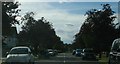
7

Gates Green Road alongside West Wickham Common
This is the view along Gates Green Road which runs along the western edge of West Wickham Common. The Common, which is on the left here, is mostly wooded and forms a continuous tract of open land with Hayes Common and the London Green Belt. West Wickham Common is noted for its wonderful ancient oak pollards. It is owned and managed by the City of London.
Image: © Marathon
Taken: 21 Oct 2012
0.13 miles
9
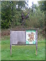
West Wickham Common from Gates Green Road
This is the view from Gates Green Road which runs along the western edge of West Wickham Common. The Common is mostly wooded and forms a continuous tract of open land with Hayes Common and the London Green Belt. West Wickham Common is noted for its wonderful ancient oak pollards and the notice gives more information about these. The tree seen here just into the woodland though has died. The Common is owned and managed by the City of London.
Image: © Marathon
Taken: 21 Oct 2012
0.15 miles
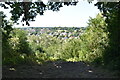
10
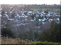
Coney Hall from West Wickham Common
On the London Loop, a rare instance where there is a gap between trees on West Wickham Common to reveal the view below. West Wickham Church can be glimpsed in the far distance on the right.
Image: © Peter S
Taken: 23 Dec 2019
0.15 miles