IMAGES TAKEN NEAR TO
Albertine Grove, WEST WICKHAM, BR4 9FR
Introduction
This page details the photographs taken nearby to Albertine Grove, BR4 9FR by members of the Geograph project.
The Geograph project started in 2005 with the aim of publishing, organising and preserving representative images for every square kilometre of Great Britain, Ireland and the Isle of Man.

There are currently over 7.5m images from over14,400 individuals and you can help contribute to the project by visiting https://www.geograph.org.uk
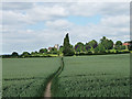
Image Map
Images are licensed for reuse under creativecommons.org/licenses/by-sa/2.0
Notes
- Clicking on the map will re-center to the selected point.
- The higher the marker number, the further away the image location is from the centre of the postcode.
Image Listing (110 Images Found)
Images are licensed for reuse under creativecommons.org/licenses/by-sa/2.0
Image
Details
Distance

2

Dead tree, West Wickham
These trees surround the graveyard of St John the Baptist.
Image: © Stephen Richards
Taken: Unknown
0.04 miles
3
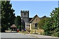
St John the Baptist, West Wickham
Seen from a footpath which runs past the church. It has some C15th parts, but is mostly Victorian.
Image: © Stephen Richards
Taken: Unknown
0.05 miles
5
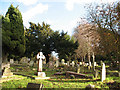
St John the Baptist, West Wickham: churchyard
The graveyard is an ancient one: the present church is 15th century but there were earlier ones.
Image: © Stephen Craven
Taken: 16 Nov 2010
0.06 miles
6

Trees, West Wickham
I was struck by this small cluster of trees. They are probably black poplars, Populus nigra (thanks to fellow Geographers tuppence and 4wd).
St John the Baptist is just visible in the background.
This is more or less the opposite view to this photo: Image]
Image: © Stephen Richards
Taken: 20 Jun 2010
0.06 miles
7

Commonwealth War Graves, West Wickham
Several war graves in the churchyard of St John.
Image: © Stephen Craven
Taken: 3 May 2014
0.06 miles
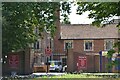
8
Chapel of the Emmaus Centre, West Wickham
A Catholic retreat centre. The chapel shown here was very new (built in 2013, I understand) and along with the buildings behind it replaced a much larger chapel shown on earlier maps (but alas not on this site).
Image: © Stephen Craven
Taken: 3 May 2014
0.07 miles
10
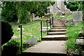
Church of St. John
Public footpath running through the churchyard.
Image: © Peter Trimming
Taken: 20 Jun 2020
0.07 miles