IMAGES TAKEN NEAR TO
Ashby Close, WEST WICKHAM, BR4 9FJ
Introduction
This page details the photographs taken nearby to Ashby Close, BR4 9FJ by members of the Geograph project.
The Geograph project started in 2005 with the aim of publishing, organising and preserving representative images for every square kilometre of Great Britain, Ireland and the Isle of Man.

There are currently over 7.5m images from over14,400 individuals and you can help contribute to the project by visiting https://www.geograph.org.uk
Image Map
Images are licensed for reuse under creativecommons.org/licenses/by-sa/2.0
Notes
- Clicking on the map will re-center to the selected point.
- The higher the marker number, the further away the image location is from the centre of the postcode.
Image Listing (28 Images Found)
Images are licensed for reuse under creativecommons.org/licenses/by-sa/2.0
Image
Details
Distance
1
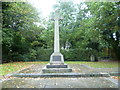
West Wickham War Memorial
West Wickham War Memorial is next to a bend in Corkscrew Hill. For the view in the other direction see http://www.geograph.org.uk/photo/3188697
Image: © Marathon
Taken: 21 Oct 2012
0.04 miles
2
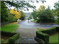
Corkscrew Hill from the steps of the West Wickham War Memorial
This was a rather damp and miserable Sunday afternoon. Corkscrew Hill is rather a nice name but something of an exaggeration when considering switchback roads in upland areas.
Image: © Marathon
Taken: 21 Oct 2012
0.06 miles
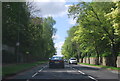
3
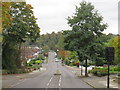
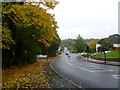
Corkscrew Hill, West Wickham
A view down Corkscrew Hill in the outer suburbs of south east London.
This image was taken in the month of October, as leaves were starting to turn golden yellow.
Image: © Malc McDonald
Taken: 20 Oct 2019
0.06 miles
4
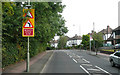
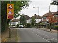
Corkscrew Hill - Steep Hill 11%
Corkscrew Hill, West Wickham. 11% steep hill down sign.
Image: © Adam Morse
Taken: 5 Aug 2009
0.09 miles
5
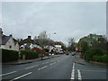
Corkscrew Hill, West Wickham
Corkscrew Hill in West Wickham, in the outer suburbs of south east London.
The road signs warn of a bend to the left, and a steep downhill gradient.
Image: © Malc McDonald
Taken: 20 Oct 2019
0.10 miles
6
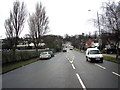
West Wickham, Kent: Corkscrew Hill
Looking northwest towards the centre of West Wickham. This part of Corkscrew Hill is straight - the 'corkscrew' bit begins further up.
Image: © Dr Neil Clifton
Taken: 24 Feb 2010
0.11 miles
7
Corkscrew Hill
This was a rather damp and miserable Sunday afternoon. Corkscrew Hill is rather a nice name but something of an exaggeration when considering switchback roads in upland areas. The trees on the horizon are around St John's Church, West Wickham.
Image: © Marathon
Taken: 21 Oct 2012
0.11 miles
10
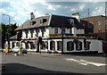
The Swan Inn, West Wickham BR4
In front of the 18th century Swan Inn there stood, until 1935, a great elm called the "Stocks Tree", marking the centre of the old village of West Wickham - at the point once known as Norwood Cross. The High Street extends to the left, in the photo, while in Station Road, just to the right of the Swan, stands the Post Office.
Image: © Philip Talmage
Taken: 7 Aug 2005
0.15 miles