IMAGES TAKEN NEAR TO
Harvest Bank Road, WEST WICKHAM, BR4 9DL
Introduction
This page details the photographs taken nearby to Harvest Bank Road, BR4 9DL by members of the Geograph project.
The Geograph project started in 2005 with the aim of publishing, organising and preserving representative images for every square kilometre of Great Britain, Ireland and the Isle of Man.

There are currently over 7.5m images from over14,400 individuals and you can help contribute to the project by visiting https://www.geograph.org.uk
Image Map
Images are licensed for reuse under creativecommons.org/licenses/by-sa/2.0
Notes
- Clicking on the map will re-center to the selected point.
- The higher the marker number, the further away the image location is from the centre of the postcode.
Image Listing (31 Images Found)
Images are licensed for reuse under creativecommons.org/licenses/by-sa/2.0
Image
Details
Distance
2
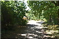
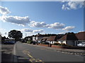
Hartfield Road, near Hayes
Hartfield Road is a residential road in the outer suburbs of south east London.
This image was taken on a late October afternoon. Leaves were changing colour and starting to fall from the trees.
Image: © Malc McDonald
Taken: 27 Oct 2019
0.11 miles
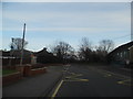
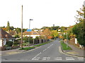
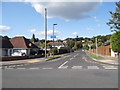
3
Roundabout at the end of Kingsway, West Wickham
At the junction of Gates Green Road
Image: © David Howard
Taken: 27 Jan 2013
0.11 miles
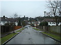
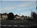
6
Hartfield Road at the junction of Gates Green Road
Image: © David Howard
Taken: 3 Aug 2014
0.11 miles