IMAGES TAKEN NEAR TO
Tiepigs Lane, WEST WICKHAM, BR4 9BT
Introduction
This page details the photographs taken nearby to Tiepigs Lane, BR4 9BT by members of the Geograph project.
The Geograph project started in 2005 with the aim of publishing, organising and preserving representative images for every square kilometre of Great Britain, Ireland and the Isle of Man.

There are currently over 7.5m images from over14,400 individuals and you can help contribute to the project by visiting https://www.geograph.org.uk
Image Map
Images are licensed for reuse under creativecommons.org/licenses/by-sa/2.0
Notes
- Clicking on the map will re-center to the selected point.
- The higher the marker number, the further away the image location is from the centre of the postcode.
Image Listing (57 Images Found)
Images are licensed for reuse under creativecommons.org/licenses/by-sa/2.0
Image
Details
Distance
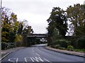
1
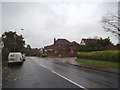
Deer Park Way
The view from Tiepigs Lane in West Wickham.
Image: © Gordon Griffiths
Taken: 14 Nov 2015
0.04 miles
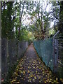
2
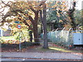
Public footpath near Hayes
A public footpath in the outer suburbs of south east London. To the right of the path is a railway embankment.
Image: © Malc McDonald
Taken: 27 Oct 2019
0.04 miles
3
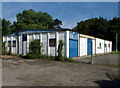
Greenacres 3rd West Wickham Scout Group BR4
Next to Coney Hall FC pavilion, Tiepigs Lane.
Image: © Philip Talmage
Taken: 23 Aug 2005
0.04 miles
4
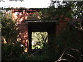
Another arch of Trepigs Lane railway Bridge
As seen from a footpath from Trepigs Lane to Pickhurst Rise.
This arch is about 40 yards left of Image
Image: © David Anstiss
Taken: 28 Aug 2011
0.04 miles
5
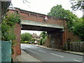
Railway bridge over Tiepigs Lane
On the Hayes branch, it lacks any readable identification at street level, but it may be inferred from the plate on the next bridge along that this is LCH 722. It is crossed by trains very slowly. An interesting feature is the wall-mounted box on the right connected to electrical conduit. Presumably once a railway phone box, it is hard to see its purpose here.
Image: © Robin Webster
Taken: 18 Jun 2011
0.05 miles
6
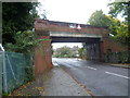
Bridge over Tiepigs Lane
This is the last bridge before the terminus of the line is reached at Hayes. The Hayes branch line from the Mid-Kent line at Elmers End was built by the West Wickham & Hayes Railway, but was sold to the South Eastern Railway on the opening day, 29th May 1882. This area saw urbanisation relatively late and usage of the line remained low until electrification in 1925.
Image: © Marathon
Taken: 21 Oct 2012
0.05 miles
7
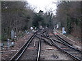
Railway lines west of Hayes (Kent) station
Image: © Mike Quinn
Taken: 11 Jan 2011
0.05 miles
8
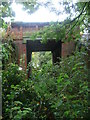
Old bridge under the railway near Tiepigs Lane
This bridge is immediately to the west of the bridge in Tiepigs Lane, just before the terminus of the line is reached at Hayes. I am not sure of its original purpose and it is very overgrown now. The Hayes branch line from the Mid-Kent line at Elmers End was built by the West Wickham & Hayes Railway, but was sold to the South Eastern Railway on the opening day, 29th May 1882. This area saw urbanisation relatively late and usage of the line remained low until electrification in 1925.
Image: © Marathon
Taken: 21 Oct 2012
0.05 miles
9
Tiepigs Bridge
The view of the railway bridge over Tiepigs Lane near Hayes Railway Station.
Image: © Gordon Griffiths
Taken: 15 Nov 2016
0.06 miles
10
Footpath alongside railway line
This footpath leads away from Tiepigs Lane with the railway embankment on the right. The Hayes branch line from the Mid-Kent line at Elmers End was built by the West Wickham & Hayes Railway, but was sold to the South Eastern Railway on the opening day, 29th May 1882. This area saw urbanisation relatively late and usage of the line remained low until electrification in 1925.
Image: © Marathon
Taken: 21 Oct 2012
0.06 miles