IMAGES TAKEN NEAR TO
Corkscrew Hill, WEST WICKHAM, BR4 9BB
Introduction
This page details the photographs taken nearby to Corkscrew Hill, BR4 9BB by members of the Geograph project.
The Geograph project started in 2005 with the aim of publishing, organising and preserving representative images for every square kilometre of Great Britain, Ireland and the Isle of Man.

There are currently over 7.5m images from over14,400 individuals and you can help contribute to the project by visiting https://www.geograph.org.uk
Image Map
Images are licensed for reuse under creativecommons.org/licenses/by-sa/2.0
Notes
- Clicking on the map will re-center to the selected point.
- The higher the marker number, the further away the image location is from the centre of the postcode.
Image Listing (39 Images Found)
Images are licensed for reuse under creativecommons.org/licenses/by-sa/2.0
Image
Details
Distance
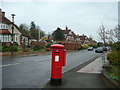
4
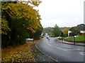
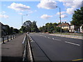
West Wickham, Kent: Corkscrew Hill
Looking northwest towards the centre of West Wickham. This part of Corkscrew Hill is straight - the 'corkscrew' bit begins further up.
Image: © Dr Neil Clifton
Taken: 24 Feb 2010
0.04 miles
5
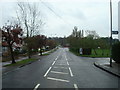
Corkscrew Hill
This was a rather damp and miserable Sunday afternoon. Corkscrew Hill is rather a nice name but something of an exaggeration when considering switchback roads in upland areas. The trees on the horizon are around St John's Church, West Wickham.
Image: © Marathon
Taken: 21 Oct 2012
0.05 miles
7
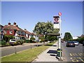
Layhams Road Bus Stop
This is in Addington Road. Layhams road is a side street just behind me.
Image: © Des Blenkinsopp
Taken: 1 Jul 2014
0.08 miles
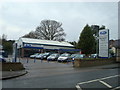
8
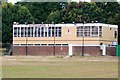
Beccehamian RFC Clubhouse
For more info on Beccehamian RFC go to http://www.beccehamians.co.uk/
Image: © Glyn Baker
Taken: 31 Aug 2016
0.08 miles
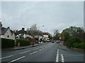
9
Addington Road, West Wickham, Kent: looking west
This is part of the A2022. In the distance is a roundabout, where a right turn leads up Corkscrew Hill to the centre of West Wickham, and a left turn up Layhams Road leads out into the countryside. Straight on, the A2022 continues as a straight road for about a mile with virtually no junctions: this stretch is known to the local 'lads' as the Mad Mile.
Image: © Dr Neil Clifton
Taken: 29 Sep 2008
0.09 miles
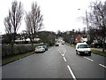
10
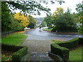
Corkscrew Hill from the steps of the West Wickham War Memorial
This was a rather damp and miserable Sunday afternoon. Corkscrew Hill is rather a nice name but something of an exaggeration when considering switchback roads in upland areas.
Image: © Marathon
Taken: 21 Oct 2012
0.10 miles