IMAGES TAKEN NEAR TO
High Street, WEST WICKHAM, BR4 0NB
Introduction
This page details the photographs taken nearby to High Street, BR4 0NB by members of the Geograph project.
The Geograph project started in 2005 with the aim of publishing, organising and preserving representative images for every square kilometre of Great Britain, Ireland and the Isle of Man.

There are currently over 7.5m images from over14,400 individuals and you can help contribute to the project by visiting https://www.geograph.org.uk
Image Map
Images are licensed for reuse under creativecommons.org/licenses/by-sa/2.0
Notes
- Clicking on the map will re-center to the selected point.
- The higher the marker number, the further away the image location is from the centre of the postcode.
Image Listing (67 Images Found)
Images are licensed for reuse under creativecommons.org/licenses/by-sa/2.0
Image
Details
Distance

3
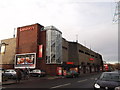
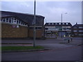
West Wickham Sainsbury's
Large superstore on the A232 High Street.
Image: © David Anstiss
Taken: 18 Dec 2011
0.05 miles
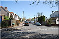
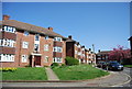
4
Manor Park Road overlooking High Street, West Wickham
Image: © David Howard
Taken: 29 Jan 2012
0.07 miles
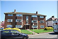
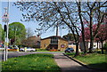
8
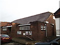
Wickham Hall, West Wickham
On Sussex Road. It is used as a chapel on Sundays, as well as meeting rooms and general hall use during the week.
Image: © David Anstiss
Taken: 18 Dec 2011
0.12 miles