IMAGES TAKEN NEAR TO
The Avenue, WEST WICKHAM, BR4 0DZ
Introduction
This page details the photographs taken nearby to The Avenue, BR4 0DZ by members of the Geograph project.
The Geograph project started in 2005 with the aim of publishing, organising and preserving representative images for every square kilometre of Great Britain, Ireland and the Isle of Man.

There are currently over 7.5m images from over14,400 individuals and you can help contribute to the project by visiting https://www.geograph.org.uk
Image Map
Images are licensed for reuse under creativecommons.org/licenses/by-sa/2.0
Notes
- Clicking on the map will re-center to the selected point.
- The higher the marker number, the further away the image location is from the centre of the postcode.
Image Listing (7 Images Found)
Images are licensed for reuse under creativecommons.org/licenses/by-sa/2.0
Image
Details
Distance
1
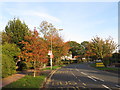
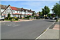
The Avenue, West Wickham
The Avenue is a road passing through the outer suburbs of south east London.
This image was taken on a sunny afternoon in late October. The sun was low in the sky, casting long shadows, while leaves were changing colour and falling from the trees.
Image: © Malc McDonald
Taken: 27 Oct 2019
0.18 miles
2
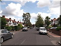
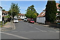
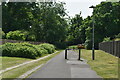
Pickhurst Rise
This long road leads from Red Lodge Road (near West Wickham railway Station) up towards Pickhurst Lane, Hayes.
Image: © David Anstiss
Taken: 28 Aug 2011
0.20 miles
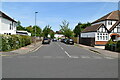
7
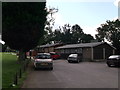
Pickhurst Rise Sports Pavilion
Clubhouse beside a large recreational ground and sports ground.
Image: © David Anstiss
Taken: 28 Aug 2011
0.25 miles