IMAGES TAKEN NEAR TO
Pickhurst Rise, WEST WICKHAM, BR4 0AB
Introduction
This page details the photographs taken nearby to Pickhurst Rise, BR4 0AB by members of the Geograph project.
The Geograph project started in 2005 with the aim of publishing, organising and preserving representative images for every square kilometre of Great Britain, Ireland and the Isle of Man.

There are currently over 7.5m images from over14,400 individuals and you can help contribute to the project by visiting https://www.geograph.org.uk
Image Map
Images are licensed for reuse under creativecommons.org/licenses/by-sa/2.0
Notes
- Clicking on the map will re-center to the selected point.
- The higher the marker number, the further away the image location is from the centre of the postcode.
Image Listing (42 Images Found)
Images are licensed for reuse under creativecommons.org/licenses/by-sa/2.0
Image
Details
Distance
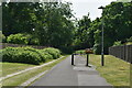
2
West Wickham Pools
West Wickham Pools, in Station Road, has one pool for teaching and another for various activities and sessions.
Image: © Philip Talmage
Taken: 7 Aug 2005
0.06 miles
3
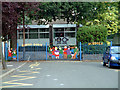
Hawes Down Junior School, West Wickham BR4
Image: © Philip Talmage
Taken: 7 Aug 2005
0.06 miles
4
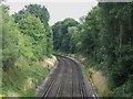
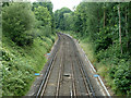
Railway tracks southeast of West Wickham station
Image: © Mike Quinn
Taken: 2 Aug 2010
0.07 miles
6
Hayes branch
East of West Wickham station.
Image: © Robin Webster
Taken: 1 Jul 2011
0.09 miles
8
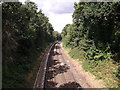
Railway line to West Wickham
This railway line runs from Hayes (via West Wickham, Eden Park, Elmers End, Clock House and Beckenham Junction).
Seen from a footbridge between The Mead and Pickhurst Hill.
Image: © David Anstiss
Taken: 28 Aug 2011
0.12 miles
10
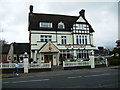
The Railway, Red Lodge Road, West Wickham
Image: © Roger Entwistle
Taken: 30 Mar 2008
0.13 miles