IMAGES TAKEN NEAR TO
Springpark Drive, BECKENHAM, BR3 6QD
Introduction
This page details the photographs taken nearby to Springpark Drive, BR3 6QD by members of the Geograph project.
The Geograph project started in 2005 with the aim of publishing, organising and preserving representative images for every square kilometre of Great Britain, Ireland and the Isle of Man.

There are currently over 7.5m images from over14,400 individuals and you can help contribute to the project by visiting https://www.geograph.org.uk
Image Map
Images are licensed for reuse under creativecommons.org/licenses/by-sa/2.0
Notes
- Clicking on the map will re-center to the selected point.
- The higher the marker number, the further away the image location is from the centre of the postcode.
Image Listing (14 Images Found)
Images are licensed for reuse under creativecommons.org/licenses/by-sa/2.0
Image
Details
Distance
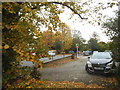
1
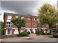
Block of town houses on Stanley Avenue
One block of three blocks along the road.
Image: © David Anstiss
Taken: 28 Aug 2011
0.06 miles
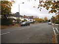
2
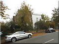
Side of house from Scotts Lane, Shortlands
The front is on Shortlands Grove
Image: © David Howard
Taken: 18 Oct 2015
0.16 miles
4
Ashmere Avenue, Beckenham
A street of detached houses.
Image: © David Hawgood
Taken: 20 Aug 2008
0.16 miles
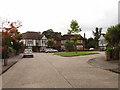
8
Quinton Close, Beckenham
Off Hayes Lane.
Image: © Robin Webster
Taken: 27 Feb 2011
0.20 miles
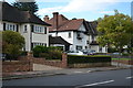
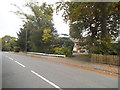
9
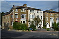
Large houses on the corner of Bromley Grove
Image: © David Martin
Taken: 31 Aug 2017
0.21 miles
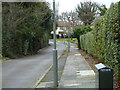
10
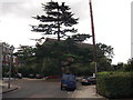
St Barnabas Church
Almost obscured by a large pine tree on Perth Road.
Image: © David Anstiss
Taken: 28 Aug 2011
0.23 miles