IMAGES TAKEN NEAR TO
Brunswick Terrace, The Knoll, BECKENHAM, BR3 5LL
Introduction
This page details the photographs taken nearby to Brunswick Terrace, The Knoll, BR3 5LL by members of the Geograph project.
The Geograph project started in 2005 with the aim of publishing, organising and preserving representative images for every square kilometre of Great Britain, Ireland and the Isle of Man.

There are currently over 7.5m images from over14,400 individuals and you can help contribute to the project by visiting https://www.geograph.org.uk
Image Map
Images are licensed for reuse under creativecommons.org/licenses/by-sa/2.0
Notes
- Clicking on the map will re-center to the selected point.
- The higher the marker number, the further away the image location is from the centre of the postcode.
Image Listing (149 Images Found)
Images are licensed for reuse under creativecommons.org/licenses/by-sa/2.0
Image
Details
Distance
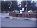
4
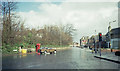
Junction of Manor Road and Wickham Road - May 1987
Photo taken from Manor Road looking across the junction. Wickham Road crosses from left to right.
Image: © David Wright
Taken: Unknown
0.07 miles
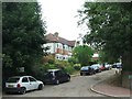
6
Corner Ways Surgery Manor Rd and Wickham Rd
Image: © N Chadwick
Taken: 9 May 2010
0.09 miles
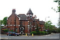
7
Crossroads at Wickham Road and Bromley Road
Image: © David Howard
Taken: 29 Jan 2012
0.09 miles
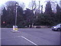
9
The corner of Wickham Road and Bromley Road, Beckenham
Image: © David Howard
Taken: 29 Jan 2012
0.10 miles