IMAGES TAKEN NEAR TO
Olyffe Drive, BECKENHAM, BR3 5HF
Introduction
This page details the photographs taken nearby to Olyffe Drive, BR3 5HF by members of the Geograph project.
The Geograph project started in 2005 with the aim of publishing, organising and preserving representative images for every square kilometre of Great Britain, Ireland and the Isle of Man.

There are currently over 7.5m images from over14,400 individuals and you can help contribute to the project by visiting https://www.geograph.org.uk
Image Map
Images are licensed for reuse under creativecommons.org/licenses/by-sa/2.0
Notes
- Clicking on the map will re-center to the selected point.
- The higher the marker number, the further away the image location is from the centre of the postcode.
Image Listing (34 Images Found)
Images are licensed for reuse under creativecommons.org/licenses/by-sa/2.0
Image
Details
Distance
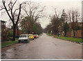
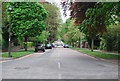
3

The Avenue, Beckenham
The Avenue is an unmade road in Beckenham.
Image: © Malc McDonald
Taken: 31 Jul 2016
0.03 miles
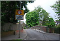
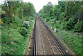
6
Railway bridge, Westgate Road, Beckenham
This narrow hump-backed bridge takes Westgate Road across a railway line.
Image: © Malc McDonald
Taken: 31 Jul 2016
0.04 miles
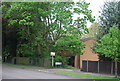
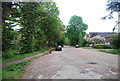
7
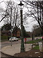
Street furniture group
Corner of Westgate Road and the Avenue in Beckenham with a Victorian sewer vent pipe combined with an early electric light complete with reflective mirrors. Close by are post box and 1970s phone booth.
Image: © sue hayton
Taken: 8 Feb 2003
0.04 miles