IMAGES TAKEN NEAR TO
The Avenue, BECKENHAM, BR3 5EY
Introduction
This page details the photographs taken nearby to The Avenue, BR3 5EY by members of the Geograph project.
The Geograph project started in 2005 with the aim of publishing, organising and preserving representative images for every square kilometre of Great Britain, Ireland and the Isle of Man.

There are currently over 7.5m images from over14,400 individuals and you can help contribute to the project by visiting https://www.geograph.org.uk
Image Map
Images are licensed for reuse under creativecommons.org/licenses/by-sa/2.0
Notes
- Clicking on the map will re-center to the selected point.
- The higher the marker number, the further away the image location is from the centre of the postcode.
Image Listing (37 Images Found)
Images are licensed for reuse under creativecommons.org/licenses/by-sa/2.0
Image
Details
Distance
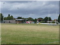
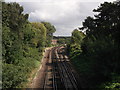
1
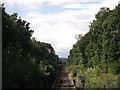
Railway to Beckenham
As seen from Image
This line leads from Bromley South (via Shortlands) towards
Catford and Beckenham (via Bellingham and Ravensbourne).
In the background is Westgate Road bridge.
Image: © David Anstiss
Taken: 28 Aug 2011
0.10 miles
2
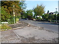
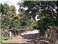
Corner of Downs Hill and Downs Bridge Road
A number of roads in Beckenham and Bromley are not made up. Downs Bridge Road, which crosses the railway between Shortlands and Beckenham Junction, is one of them. This view is looking up Downs Hill from the corner of Downs Bridge Road.
Image: © Marathon
Taken: 19 Aug 2011
0.11 miles
3
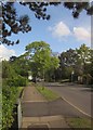
Downs Hill, Ravensbourne
A road of detached houses, sufficiently set back from the road not to appear in this image.
Image: © Derek Harper
Taken: 9 May 2013
0.11 miles
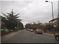
4
Downs Bridge Road, Bromley Park
A number of roads in Beckenham and Bromley are not made up. Downs Bridge Road, which crosses the railway between Shortlands and Beckenham Junction, is one of them.
Image: © Marathon
Taken: 19 Aug 2011
0.11 miles
5
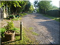
Downs Bridge Road
This unmade road leads from Bromley Road towards Downs Hill.
It leads over the railway line between Ravensbourne and Shortlands.
Image: © David Anstiss
Taken: 28 Aug 2011
0.11 miles
7
Albemarle Road, Beckenham
Compare with the same view in 1992. Many of the fences have gone and the blocks of flats here are mainly recently built. http://www.geograph.org.uk/photo/4708564
Image: © David Howard
Taken: 18 Oct 2015
0.12 miles
8
Albemarle Road, Beckenham, 1992
Quite a lot has changed since 1992, although with the trees here it's not possible to see. Most of the buildings have been replaced with blocks of flats and most of the fences have been removed to create open lawns.
Image: © David Howard
Taken: Unknown
0.12 miles
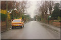
9
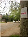
The Avenue, Beckenham
The notice warns "unmade road; PLEASE drive slowly". You'd be foolish not to; the surface is a lot more irregular than it appears from this image. Still, it must dissuade rat-runners.
Image: © Derek Harper
Taken: 9 May 2013
0.14 miles
10
Railway to Shortlands
As seen from Image
This line leads from Catford (via Bellingham and Ravensbourne) towards Bromley South.
Image: © David Anstiss
Taken: 28 Aug 2011
0.14 miles