IMAGES TAKEN NEAR TO
Churchfields Road, BECKENHAM, BR3 4QR
Introduction
This page details the photographs taken nearby to Churchfields Road, BR3 4QR by members of the Geograph project.
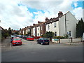
The Geograph project started in 2005 with the aim of publishing, organising and preserving representative images for every square kilometre of Great Britain, Ireland and the Isle of Man.

There are currently over 7.5m images from over14,400 individuals and you can help contribute to the project by visiting https://www.geograph.org.uk
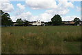
Image Map
Images are licensed for reuse under creativecommons.org/licenses/by-sa/2.0
Notes
- Clicking on the map will re-center to the selected point.
- The higher the marker number, the further away the image location is from the centre of the postcode.
Image Listing (80 Images Found)
Images are licensed for reuse under creativecommons.org/licenses/by-sa/2.0
Image
Details
Distance
1
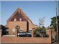
Saint Augustine of Canterbury, Beckenham
This parish church on Churchfields Road, was closed in 1983 and then converted into houses/flats.
It was once St.George's Mission Church built in 1887.
Image: © David Anstiss
Taken: 16 Oct 2011
0.03 miles
2
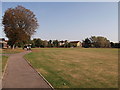
Path in Churchfields Recreational Ground
This path leads from Churchfields Road through the open-space park towards Kendal Avenue.
Image: © David Anstiss
Taken: 16 Oct 2011
0.07 miles
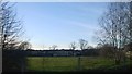
3
Church Fields Recreational Ground
Recreational Ground close to Churchfields Road. A path leads left to Florence Road and Kendal Avenue.
Image: © David Anstiss
Taken: 16 Oct 2011
0.07 miles
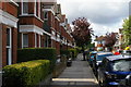
4
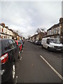
Blandford Road
The view from Avenue Road in Beckenham.
Image: © Gordon Griffiths
Taken: 16 Nov 2015
0.10 miles
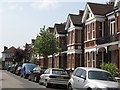
5
Blandford Avenue, near Beckenham
Blandford Avenue is a short residential cul-de-sac near Beckenham, in south-east London's suburbs.
Image: © Malc McDonald
Taken: 21 Aug 2016
0.10 miles
6
Recreation ground south of Clock House station, from the train
Image: © Christopher Hilton
Taken: 7 Mar 2014
0.10 miles
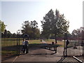
9
Churchfields Recreation Ground, Penge
On the hill in the distance, the Crystal Palace TV transmitter mast.
Image: © Christopher Hilton
Taken: 30 Jul 2015
0.11 miles
10
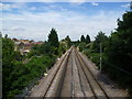
View from the footbridge at Avenue Road Tramlink stop
This view is looking towards Beckenham Junction, with the Tramlink stop behind. The right hand track is for Tramlink opened in 2000 and the left hand track is for the railway line between Birkbeck and Beckenham Junction, opened in 1858 as a double track. The up line was taken out of use in February 1983 which eventually gave the space for Tramlink.
Image: © Marathon
Taken: 25 Jul 2011
0.11 miles