IMAGES TAKEN NEAR TO
Durban Road, BECKENHAM, BR3 4EY
Introduction
This page details the photographs taken nearby to Durban Road, BR3 4EY by members of the Geograph project.
The Geograph project started in 2005 with the aim of publishing, organising and preserving representative images for every square kilometre of Great Britain, Ireland and the Isle of Man.

There are currently over 7.5m images from over14,400 individuals and you can help contribute to the project by visiting https://www.geograph.org.uk
Image Map
Images are licensed for reuse under creativecommons.org/licenses/by-sa/2.0
Notes
- Clicking on the map will re-center to the selected point.
- The higher the marker number, the further away the image location is from the centre of the postcode.
Image Listing (41 Images Found)
Images are licensed for reuse under creativecommons.org/licenses/by-sa/2.0
Image
Details
Distance
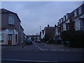
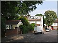
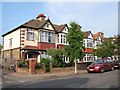
2
Queens Road at the junction of Cedars Road
Image: © David Howard
Taken: 6 Apr 2015
0.15 miles
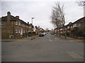
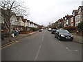
3
Cedars Road at the junction of Queens Road
Image: © David Howard
Taken: 6 Apr 2015
0.16 miles
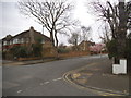
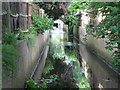
5
Queen's Road, BR3
The low brick wall in the foreground (left) marks the course of Image
Image: © Mike Quinn
Taken: 25 May 2010
0.17 miles
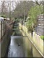
7
The Chaffinch Brook north of Queen's Road, BR3
Image: © Mike Quinn
Taken: 25 May 2010
0.19 miles
8
The Chaffinch Brook south of Cedars Road, BR3
Image: © Mike Quinn
Taken: 9 Apr 2010
0.19 miles
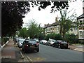
9
Hampden Road, BR3 (2)
At its junction with Hampden Avenue.
Image: © Mike Quinn
Taken: 25 May 2010
0.19 miles
10
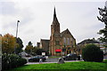
Beckenham Baptist Church
In the foreground is the Bromley Millennium Rock, originating from Lochinver in North West Scotland and presented to the people of Bromley by The Highland Council.
Image: © Bill Boaden
Taken: 10 Oct 2015
0.20 miles