IMAGES TAKEN NEAR TO
Upper Elmers End Road, BECKENHAM, BR3 4AW
Introduction
This page details the photographs taken nearby to Upper Elmers End Road, BR3 4AW by members of the Geograph project.
The Geograph project started in 2005 with the aim of publishing, organising and preserving representative images for every square kilometre of Great Britain, Ireland and the Isle of Man.

There are currently over 7.5m images from over14,400 individuals and you can help contribute to the project by visiting https://www.geograph.org.uk
Image Map
Images are licensed for reuse under creativecommons.org/licenses/by-sa/2.0
Notes
- Clicking on the map will re-center to the selected point.
- The higher the marker number, the further away the image location is from the centre of the postcode.
Image Listing (30 Images Found)
Images are licensed for reuse under creativecommons.org/licenses/by-sa/2.0
Image
Details
Distance
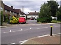
1
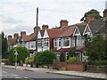
Upper Elmers End Road, BR3
The course of the Chaffinch Brook runs behind the houses on the east side of the road.
Image: © Mike Quinn
Taken: 2 Aug 2010
0.03 miles
4
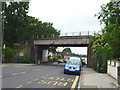
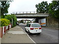
Elmer's End: Railway bridge over Upper Elmer's End Road
Looking north. The road is the A214.
Image: © Dr Neil Clifton
Taken: 2 Jun 2012
0.08 miles
5
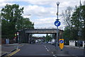
Elmer's End: Railway bridge over Upper Elmer's End Road
Looking south. The road is the A214
Image: © Dr Neil Clifton
Taken: 2 Jun 2012
0.08 miles
6
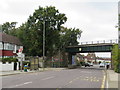
Railway bridge over Elmer's End road
The A214 Elmer's End Road leads from Eden Park / West Wickham to Elmer's End.
It passes under the railway between Elmer's End and Eden Park.
Image: © David Anstiss
Taken: 16 Oct 2011
0.08 miles
7
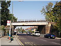
Upper Elmers End Road, Elmers End
Upper Elmers End Road in the outer suburbs of south east London. The road forms part of the route of the A214. A bridge carries a railway line across the road.
Image: © Malc McDonald
Taken: 20 Oct 2019
0.08 miles
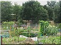
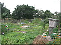
10
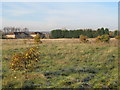
Scrubland, Elmers End
This land adjoining Beckenham Rugby Club is shown on most maps as Sports Ground, Cricket Club and Bowling Green. However it has been scrubland for a few years now, with a circular path around the edge used mostly by dog walkers. The TV masts at Croydon Transmitting Station, to the left of picture, and Crystal Palace Transmitting Station to the right, can be seen in the distance.
Image: © Paul E Smith
Taken: 28 Nov 2010
0.11 miles