IMAGES TAKEN NEAR TO
Gordon Road, BECKENHAM, BR3 3QF
Introduction
This page details the photographs taken nearby to Gordon Road, BR3 3QF by members of the Geograph project.
The Geograph project started in 2005 with the aim of publishing, organising and preserving representative images for every square kilometre of Great Britain, Ireland and the Isle of Man.

There are currently over 7.5m images from over14,400 individuals and you can help contribute to the project by visiting https://www.geograph.org.uk
Image Map
Images are licensed for reuse under creativecommons.org/licenses/by-sa/2.0
Notes
- Clicking on the map will re-center to the selected point.
- The higher the marker number, the further away the image location is from the centre of the postcode.
Image Listing (5 Images Found)
Images are licensed for reuse under creativecommons.org/licenses/by-sa/2.0
Image
Details
Distance
1
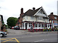
Elmer's End: The 'William IV'
He must have been a popular king, if the number of public houses named after him is any guide. According to yesterday's 'Guardian', he fathered ten illegitimate children before ascending the throne.
Image: © Dr Neil Clifton
Taken: 2 Jun 2012
0.11 miles
4
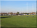
Beckenham Rugby Club
View across the rugby pitches. The clubhouse is in the distance.
Image: © Paul E Smith
Taken: 28 Nov 2010
0.22 miles
5
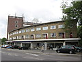
Shops and Flats on Croydon Road, Elmers End
Since this photograph was taken in 2011, the taller building behind has been extended upwards, with the addition of two extra floors and a curved roof.
Image: © Stephen Armstrong
Taken: 27 May 2011
0.23 miles