IMAGES TAKEN NEAR TO
Maibeth Gardens, BECKENHAM, BR3 3FF
Introduction
This page details the photographs taken nearby to Maibeth Gardens, BR3 3FF by members of the Geograph project.
The Geograph project started in 2005 with the aim of publishing, organising and preserving representative images for every square kilometre of Great Britain, Ireland and the Isle of Man.

There are currently over 7.5m images from over14,400 individuals and you can help contribute to the project by visiting https://www.geograph.org.uk
Image Map
Images are licensed for reuse under creativecommons.org/licenses/by-sa/2.0
Notes
- Clicking on the map will re-center to the selected point.
- The higher the marker number, the further away the image location is from the centre of the postcode.
Image Listing (56 Images Found)
Images are licensed for reuse under creativecommons.org/licenses/by-sa/2.0
Image
Details
Distance
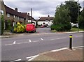
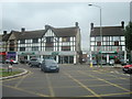
2
Upper Elmers End Road, BR3 (2)
North of the junction with Balmoral Avenue. The course of the Chaffinch Brook runs behind the houses on the east side of the road.
Image: © Mike Quinn
Taken: 2 Aug 2010
0.08 miles
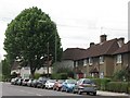
4
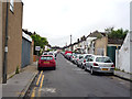
Elmer's End: Eden Road
The large number of parked motor cars gives this road a scruffy appearance.
Image: © Dr Neil Clifton
Taken: 2 Jun 2012
0.08 miles
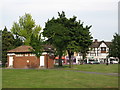
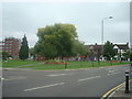
7
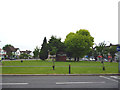
Elmer's End Green
The trees, (of course) are not elms. The brick building is public conveniences, but they are (of course) permanently closed
Image: © Dr Neil Clifton
Taken: 2 Jun 2012
0.11 miles