IMAGES TAKEN NEAR TO
Whitecroft Way, BECKENHAM, BR3 3AG
Introduction
This page details the photographs taken nearby to Whitecroft Way, BR3 3AG by members of the Geograph project.
The Geograph project started in 2005 with the aim of publishing, organising and preserving representative images for every square kilometre of Great Britain, Ireland and the Isle of Man.

There are currently over 7.5m images from over14,400 individuals and you can help contribute to the project by visiting https://www.geograph.org.uk
Image Map
Images are licensed for reuse under creativecommons.org/licenses/by-sa/2.0
Notes
- Clicking on the map will re-center to the selected point.
- The higher the marker number, the further away the image location is from the centre of the postcode.
Image Listing (33 Images Found)
Images are licensed for reuse under creativecommons.org/licenses/by-sa/2.0
Image
Details
Distance
1
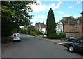
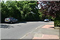
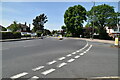
Whitecroft Way intersects Hayes Way
Although Whitecroft Way is marked as the major road here, to the left it is a dead-end. This was not always the case, as it has been blocked off with bollards at its former junction with Hayes Lane.
Image: © Robin Webster
Taken: 27 Feb 2011
0.06 miles