IMAGES TAKEN NEAR TO
Brackley Road, BECKENHAM, BR3 1UA
Introduction
This page details the photographs taken nearby to Brackley Road, BR3 1UA by members of the Geograph project.
The Geograph project started in 2005 with the aim of publishing, organising and preserving representative images for every square kilometre of Great Britain, Ireland and the Isle of Man.

There are currently over 7.5m images from over14,400 individuals and you can help contribute to the project by visiting https://www.geograph.org.uk
Image Map
Images are licensed for reuse under creativecommons.org/licenses/by-sa/2.0
Notes
- Clicking on the map will re-center to the selected point.
- The higher the marker number, the further away the image location is from the centre of the postcode.
Image Listing (64 Images Found)
Images are licensed for reuse under creativecommons.org/licenses/by-sa/2.0
Image
Details
Distance
3
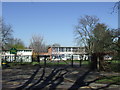
Worsley Bridge Junior School, Beckenham
Image: © Malc McDonald
Taken: 19 Mar 2011
0.06 miles
7
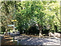
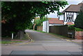
Green Chain Walk on Brackley Road
The long distance path leads straight on towards Copers Cope Road, or right along Worsley Bridge road to Stumps Hill.
Image: © David Anstiss
Taken: 16 Oct 2011
0.09 miles
8
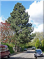
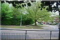
Pine, Abbey Lane
No doubt a member of the pine family (Pinaceae), and probably a species of pine but there are many and the differences are subtle, at least too subtle for me.
Image: © Stephen Richards
Taken: 12 May 2012
0.09 miles
9
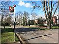
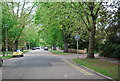
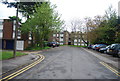
Brackley Road, Beckenham
A roadside section along the Capital Ring Path.
Image: © Des Blenkinsopp
Taken: 24 Feb 2016
0.10 miles
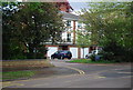
10
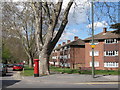
Brackley Road, Beckenham
Shows the location of Image
Image: © Mike Quinn
Taken: 9 Apr 2008
0.10 miles