IMAGES TAKEN NEAR TO
Kent House Road, BECKENHAM, BR3 1JY
Introduction
This page details the photographs taken nearby to Kent House Road, BR3 1JY by members of the Geograph project.
The Geograph project started in 2005 with the aim of publishing, organising and preserving representative images for every square kilometre of Great Britain, Ireland and the Isle of Man.

There are currently over 7.5m images from over14,400 individuals and you can help contribute to the project by visiting https://www.geograph.org.uk
Image Map
Images are licensed for reuse under creativecommons.org/licenses/by-sa/2.0
Notes
- Clicking on the map will re-center to the selected point.
- The higher the marker number, the further away the image location is from the centre of the postcode.
Image Listing (73 Images Found)
Images are licensed for reuse under creativecommons.org/licenses/by-sa/2.0
Image
Details
Distance
1

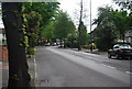
Green Chain Walk off Kent House Rd
Also the Capital Ring route.
Image: © N Chadwick
Taken: 9 May 2010
0.01 miles
2
Borough of Beckenham sign at the entrance to path across playing fields
The Municipal Borough of Beckenham was swallowed up in the new London Borough of Bromley when London local government was rearranged in 1965.
To be honest, what this path (seen at Image) needs is a sign concerning not bicycles but dog-fouling: specifically, reminding dog-owners that bagging up the waste is unhelpful if you then leave the bags lying around where they were filled.
Image: © Christopher Hilton
Taken: 8 May 2016
0.01 miles
8
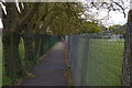
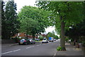
Path across playing fields
This path links Cator Road and Kent House Road, giving no access to the playing fields beside it. The combined Green Chain Walk / Capital Ring long distance path uses this route.
Image: © Christopher Hilton
Taken: 2 May 2016
0.07 miles
9
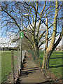
Capital Ring between the fences
The Capital Ring and Green Chain paths share this right of way across the middle of a school sports field.
Image: © Des Blenkinsopp
Taken: 24 Feb 2016
0.08 miles
