IMAGES TAKEN NEAR TO
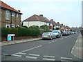
Brooklyn Road, BROMLEY, BR2 9SD
Introduction
This page details the photographs taken nearby to Brooklyn Road, BR2 9SD by members of the Geograph project.
The Geograph project started in 2005 with the aim of publishing, organising and preserving representative images for every square kilometre of Great Britain, Ireland and the Isle of Man.

There are currently over 7.5m images from over14,400 individuals and you can help contribute to the project by visiting https://www.geograph.org.uk
Image Map
Images are licensed for reuse under creativecommons.org/licenses/by-sa/2.0
Notes
- Clicking on the map will re-center to the selected point.
- The higher the marker number, the further away the image location is from the centre of the postcode.
Image Listing (47 Images Found)
Images are licensed for reuse under creativecommons.org/licenses/by-sa/2.0
Image
Details
Distance
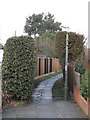
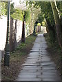
2
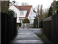
Footpath south of Brooklyn Road, BR2 (3)
This footpath is on the line of the east branch of the River Ravensbourne; it prevents access between the housing to its east and west - see the satellite image http://wtp2.appspot.com/wheresthepath.htm?lat=51.392457582448934&lon=0.04201540790273475&gz=16&oz=9>=1.
Image: © Mike Quinn
Taken: 12 Mar 2010
0.05 miles
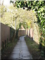
3
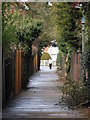
Footpath south of Brooklyn Road, BR2
This footpath is on the line of the east branch of the River Ravensbourne; it prevents access between the housing to its east and west - see the satellite image http://wtp2.appspot.com/wheresthepath.htm?lat=51.392457582448934&lon=0.04201540790273475&gz=16&oz=9>=1.
Image: © Mike Quinn
Taken: 12 Mar 2010
0.05 miles
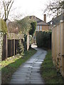
4
Footpath at the east end of Brooklyn Road, BR2
This footpath is on the line of the east branch of the River Ravensbourne; it prevents access between the housing to its east and west - see the satellite image http://wtp2.appspot.com/wheresthepath.htm?lat=51.39302702673192&lon=0.041391849517822266&gz=17&oz=9>=1.
Image: © Mike Quinn
Taken: 12 Mar 2010
0.06 miles
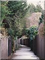
6
Footpath north of Brooklyn Road, BR2
This footpath is on the line of the east branch of the River Ravensbourne; it prevents access between the housing to its east and west - see the satellite image http://wtp2.appspot.com/wheresthepath.htm?lat=51.392457582448934&lon=0.04201540790273475&gz=16&oz=9>=1.
Image: © Mike Quinn
Taken: 12 Mar 2010
0.06 miles
7
Footpath south of Brooklyn Road, BR2 (2)
This footpath is on the line of the east branch of the River Ravensbourne; it prevents access between the housing to its east and west - see the satellite image http://wtp2.appspot.com/wheresthepath.htm?lat=51.392457582448934&lon=0.04201540790273475&gz=16&oz=9>=1.
Image: © Mike Quinn
Taken: 12 Mar 2010
0.06 miles
8
Footpath south of Blenheim Road, BR2
This footpath is on the line of the east branch of the River Ravensbourne; it prevents access between the housing to its east and west - see the satellite image http://wtp2.appspot.com/wheresthepath.htm?lat=51.392457582448934&lon=0.04201540790273475&gz=16&oz=9>=1.
Image: © Mike Quinn
Taken: 12 Mar 2010
0.08 miles
9
Footpath north of Brooklyn Road, BR2 (2)
This footpath is on the line of the east branch of the River Ravensbourne; it prevents access between the housing to its east and west - see the satellite image http://wtp2.appspot.com/wheresthepath.htm?lat=51.392457582448934&lon=0.04201540790273475&gz=16&oz=9>=1.
Image: © Mike Quinn
Taken: 12 Mar 2010
0.09 miles