IMAGES TAKEN NEAR TO
Drake Mews, BROMLEY, BR2 9NA
Introduction
This page details the photographs taken nearby to Drake Mews, BR2 9NA by members of the Geograph project.
The Geograph project started in 2005 with the aim of publishing, organising and preserving representative images for every square kilometre of Great Britain, Ireland and the Isle of Man.

There are currently over 7.5m images from over14,400 individuals and you can help contribute to the project by visiting https://www.geograph.org.uk
Image Map
Images are licensed for reuse under creativecommons.org/licenses/by-sa/2.0
Notes
- Clicking on the map will re-center to the selected point.
- The higher the marker number, the further away the image location is from the centre of the postcode.
Image Listing (70 Images Found)
Images are licensed for reuse under creativecommons.org/licenses/by-sa/2.0
Image
Details
Distance

6
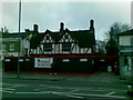
The Five Bells Public House
Pub closed for redevelopment
Image: © Alex McGregor
Taken: 19 Feb 2010
0.11 miles

10
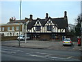
The Five Bells Public House, Bromley Common, Kent
Image: © Stacey Harris
Taken: 1 Jan 2009
0.12 miles