IMAGES TAKEN NEAR TO
Streamside Close, BROMLEY, BR2 9BH
Introduction
This page details the photographs taken nearby to Streamside Close, BR2 9BH by members of the Geograph project.
The Geograph project started in 2005 with the aim of publishing, organising and preserving representative images for every square kilometre of Great Britain, Ireland and the Isle of Man.

There are currently over 7.5m images from over14,400 individuals and you can help contribute to the project by visiting https://www.geograph.org.uk
Image Map
Images are licensed for reuse under creativecommons.org/licenses/by-sa/2.0
Notes
- Clicking on the map will re-center to the selected point.
- The higher the marker number, the further away the image location is from the centre of the postcode.
Image Listing (90 Images Found)
Images are licensed for reuse under creativecommons.org/licenses/by-sa/2.0
Image
Details
Distance
1
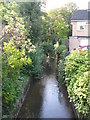
The River Ravensbourne south of Streamside Close, BR2
Image: © Mike Quinn
Taken: 8 Oct 2009
0.02 miles
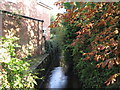
2
Streamside Close, BR2
An apt name, as the River Ravensbourne crosses underneath - the green railings mark the bridge - see Image and Image; and it is a cul de sac.
Image: © Mike Quinn
Taken: 8 Oct 2009
0.02 miles
3
The River Ravensbourne north of Streamside Close, BR2
Image: © Mike Quinn
Taken: 8 Oct 2009
0.03 miles
4
Hayes Road, BR2
The low wooden fence in the foreground (right) marks where a tributary of the River Ravensbourne - just visible about 150 m west: Image - passes under the road.
Image: © Mike Quinn
Taken: 11 Jan 2011
0.06 miles
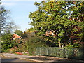
7

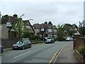
New Farm Avenue, Bromley
New Farm Avenue is a residential road in Bromley, in south east London's outer suburbs.
Image: © Malc McDonald
Taken: 31 Jul 2016
0.10 miles
8

The River Ravensbourne west of Sandford Road, BR2 (2)
Image: © Mike Quinn
Taken: 12 Nov 2009
0.11 miles
9
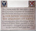
St Mark, Westmoreland Road, Bromley - Foundation stone
Image: © John Salmon
Taken: 22 Mar 2010
0.12 miles
10
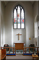
St Mark, Westmoreland Road, Bromley - South chapel
Image: © John Salmon
Taken: 22 Mar 2010
0.12 miles