IMAGES TAKEN NEAR TO
Church Lane, BROMLEY, BR2 8LB
Introduction
This page details the photographs taken nearby to Church Lane, BR2 8LB by members of the Geograph project.
The Geograph project started in 2005 with the aim of publishing, organising and preserving representative images for every square kilometre of Great Britain, Ireland and the Isle of Man.

There are currently over 7.5m images from over14,400 individuals and you can help contribute to the project by visiting https://www.geograph.org.uk
Image Map
Images are licensed for reuse under creativecommons.org/licenses/by-sa/2.0
Notes
- Clicking on the map will re-center to the selected point.
- The higher the marker number, the further away the image location is from the centre of the postcode.
Image Listing (51 Images Found)
Images are licensed for reuse under creativecommons.org/licenses/by-sa/2.0
Image
Details
Distance
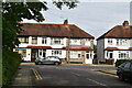
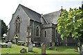
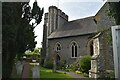
9
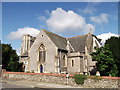
Holy Trinity Church, Bromley
On the junction of Church Lane (in front) and the A21 Bromley Common (road).
Image: © David Anstiss
Taken: 28 Aug 2011
0.07 miles
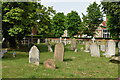
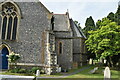
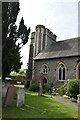
10
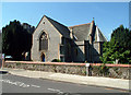
Holy Trinity Church, Bromley Common BR2
Holy Trinity Church was built in 1839. It stands by the busy A21, at the junction with the A233 Oakley Road towards Keston and Biggin Hill.
Image: © Philip Talmage
Taken: 31 Aug 2005
0.08 miles