IMAGES TAKEN NEAR TO
Rayfield Close, BROMLEY, BR2 8JU
Introduction
This page details the photographs taken nearby to Rayfield Close, BR2 8JU by members of the Geograph project.
The Geograph project started in 2005 with the aim of publishing, organising and preserving representative images for every square kilometre of Great Britain, Ireland and the Isle of Man.

There are currently over 7.5m images from over14,400 individuals and you can help contribute to the project by visiting https://www.geograph.org.uk
Image Map
Images are licensed for reuse under creativecommons.org/licenses/by-sa/2.0
Notes
- Clicking on the map will re-center to the selected point.
- The higher the marker number, the further away the image location is from the centre of the postcode.
Image Listing (13 Images Found)
Images are licensed for reuse under creativecommons.org/licenses/by-sa/2.0
Image
Details
Distance
2
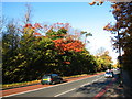
A21 in Autumn
A morning picture after 10.00, when the buses only lane may be used again. The A21 is a 'red route', notice the double red lines.
Image: © Mrs V Bryant
Taken: 19 Nov 2006
0.13 miles
3
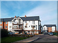
New Housing, Bromley Common
Terraced houses, paved walkways, old iron lamp post and the mill at the top of the street.
19th century going on 21st?
This is just off the A21 in Bromley Common and it's so new it's not on the map yet.
Image: © Des Blenkinsopp
Taken: 5 Dec 2011
0.13 miles
5
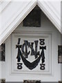
Date stone on the North Lodge to Oakley House, Bromley Common (A21), BR2
The location of this date stone is shown in Image
Image: © Mike Quinn
Taken: 12 Nov 2009
0.16 miles
6
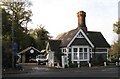
The North Lodge to Oakley House, Bromley Common (A21), BR2
Image: © Mike Quinn
Taken: 12 Nov 2009
0.16 miles
7
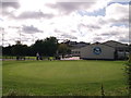
Bromley Golf Centre
Bromley Public Golf Course clubhouse on Magpie Hall Lane.
In the background is the unusual roof of Bishop Justus School.
Image: © David Anstiss
Taken: 28 Aug 2011
0.20 miles
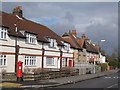
8
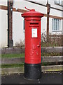
George V postbox, Magpie Hall Lane / Manor Way, BR2
This postbox sports the remains of a "post office direction" sign on its cap. Its location is shown in Image
Image: © Mike Quinn
Taken: 12 Mar 2010
0.21 miles
9
Magpie Hall Lane, BR2
To the east of Manor Way; shows the location of Image
Image: © Mike Quinn
Taken: 12 Mar 2010
0.22 miles
10
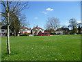
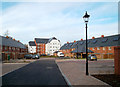
A green looking towards Turpington Lane
This small green is surrounded by Turpington Lane, Crown Lane and Lavender Close. In this view Turpington Close is ahead with a 336 bus on its way from Catford to Locksbottom.
Image: © Marathon
Taken: 9 Apr 2014
0.23 miles