IMAGES TAKEN NEAR TO
Manor Way, BROMLEY, BR2 8ES
Introduction
This page details the photographs taken nearby to Manor Way, BR2 8ES by members of the Geograph project.
The Geograph project started in 2005 with the aim of publishing, organising and preserving representative images for every square kilometre of Great Britain, Ireland and the Isle of Man.

There are currently over 7.5m images from over14,400 individuals and you can help contribute to the project by visiting https://www.geograph.org.uk
Image Map
Images are licensed for reuse under creativecommons.org/licenses/by-sa/2.0
Notes
- Clicking on the map will re-center to the selected point.
- The higher the marker number, the further away the image location is from the centre of the postcode.
Image Listing (15 Images Found)
Images are licensed for reuse under creativecommons.org/licenses/by-sa/2.0
Image
Details
Distance
1
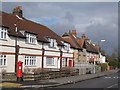
Magpie Hall Lane, BR2
To the east of Manor Way; shows the location of Image
Image: © Mike Quinn
Taken: 12 Mar 2010
0.09 miles
2
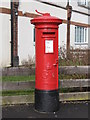
George V postbox, Magpie Hall Lane / Manor Way, BR2
This postbox sports the remains of a "post office direction" sign on its cap. Its location is shown in Image
Image: © Mike Quinn
Taken: 12 Mar 2010
0.10 miles
3
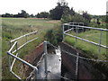
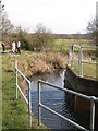
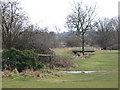
Drain and Bromley Public Golf Course
This ditch and field drain runs from Clay wood and Sparrow Wood, through Bromley Public Golf Course towards Magpie Hill Lane.
Image: © David Anstiss
Taken: 28 Aug 2011
0.11 miles
4
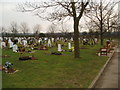
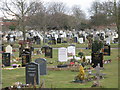
St. Luke's Cemetery, Bromley, Kent
Apart from this cemetery the rest of this grid square is occupied by housing.
Image: © Dr Neil Clifton
Taken: 15 Mar 2006
0.11 miles
6
St. Luke's Cemetery, Magpie Hall Lane, BR2 (2)
Image: © Mike Quinn
Taken: 12 Mar 2010
0.12 miles
7
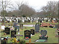
St. Luke's Cemetery, Magpie Hall Lane, BR2
Image: © Mike Quinn
Taken: 12 Mar 2010
0.13 miles
8
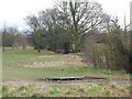
Bromley Public Golf Course east of Magpie Hall Lane, BR2
The line of trees marks a drain that feeds into the Image
Image: © Mike Quinn
Taken: 12 Mar 2010
0.15 miles
9
The River Ravensbourne - East Branch, on Bromley Public Golf Course
Image: © Mike Quinn
Taken: 12 Mar 2010
0.16 miles
10
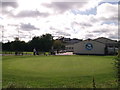
Bromley Golf Centre
Bromley Public Golf Course clubhouse on Magpie Hall Lane.
In the background is the unusual roof of Bishop Justus School.
Image: © David Anstiss
Taken: 28 Aug 2011
0.21 miles