IMAGES TAKEN NEAR TO
Hurstdene Avenue, BROMLEY, BR2 7JJ
Introduction
This page details the photographs taken nearby to Hurstdene Avenue, BR2 7JJ by members of the Geograph project.
The Geograph project started in 2005 with the aim of publishing, organising and preserving representative images for every square kilometre of Great Britain, Ireland and the Isle of Man.

There are currently over 7.5m images from over14,400 individuals and you can help contribute to the project by visiting https://www.geograph.org.uk
Image Map
Images are licensed for reuse under creativecommons.org/licenses/by-sa/2.0
Notes
- Clicking on the map will re-center to the selected point.
- The higher the marker number, the further away the image location is from the centre of the postcode.
Image Listing (96 Images Found)
Images are licensed for reuse under creativecommons.org/licenses/by-sa/2.0
Image
Details
Distance
3
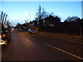
Hayes Hill Road at the junction of Pickhurst Lane
Image: © David Howard
Taken: 29 Dec 2013
0.10 miles
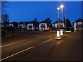
4
Tiepigs Lane, Hayes
The railway bridge is also the boundary with West Wickham
Image: © David Howard
Taken: 29 Dec 2013
0.10 miles
5
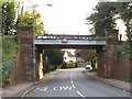
Railway bridge near Hayes
A railway bridge across Tiepigs Lane, near Hayes in the outer suburbs of south east London. A warning sign on the bridge indicates a height limit of 14 feet and 6 inches.
The railway which crosses this bridge is a suburban branch line which reaches a terminus at Hayes.
Image: © Malc McDonald
Taken: 27 Oct 2019
0.11 miles
6
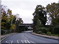
Tiepigs Bridge
The view of the railway bridge over Tiepigs Lane near Hayes Railway Station.
Image: © Gordon Griffiths
Taken: 15 Nov 2016
0.11 miles
7
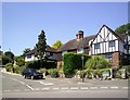
Hayes Hill
A good example of suburban mock-Tudor styling.
Image: © Des Blenkinsopp
Taken: 30 Jun 2014
0.11 miles
8
Railway lines west of Hayes (Kent) station
Image: © Mike Quinn
Taken: 11 Jan 2011
0.11 miles
9
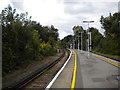
Outer end of platforms, Hayes station
Often referred to as Hayes (Kent), to differentiate it from Hayes & Harlington (which is also in Greater London, but west rather than south east). Looking towards London.
Image: © Richard Vince
Taken: 28 Sep 2019
0.12 miles
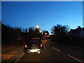
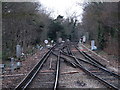
10
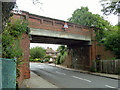
Railway bridge over Tiepigs Lane
On the Hayes branch, it lacks any readable identification at street level, but it may be inferred from the plate on the next bridge along that this is LCH 722. It is crossed by trains very slowly. An interesting feature is the wall-mounted box on the right connected to electrical conduit. Presumably once a railway phone box, it is hard to see its purpose here.
Image: © Robin Webster
Taken: 18 Jun 2011
0.12 miles