IMAGES TAKEN NEAR TO
Hayes Hill, BROMLEY, BR2 7HW
Introduction
This page details the photographs taken nearby to Hayes Hill, BR2 7HW by members of the Geograph project.
The Geograph project started in 2005 with the aim of publishing, organising and preserving representative images for every square kilometre of Great Britain, Ireland and the Isle of Man.

There are currently over 7.5m images from over14,400 individuals and you can help contribute to the project by visiting https://www.geograph.org.uk
Image Map
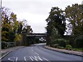
Images are licensed for reuse under creativecommons.org/licenses/by-sa/2.0
Notes
- Clicking on the map will re-center to the selected point.
- The higher the marker number, the further away the image location is from the centre of the postcode.
Image Listing (28 Images Found)
Images are licensed for reuse under creativecommons.org/licenses/by-sa/2.0
Image
Details
Distance
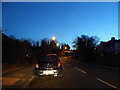
1
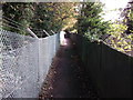
Footpath to Trepigs Lane
This path leads from Pickhurst Rise / The Mead towards the lane in Hayes.
It leads beside the railway, (in a deep cutting) heading towards Hayes Railway Station.
Image: © David Anstiss
Taken: 28 Aug 2011
0.08 miles
2
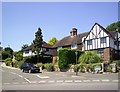
Hayes Hill
A good example of suburban mock-Tudor styling.
Image: © Des Blenkinsopp
Taken: 30 Jun 2014
0.10 miles
3
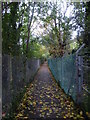
Footpath alongside railway line
This footpath leads away from Tiepigs Lane with the railway embankment on the right. The Hayes branch line from the Mid-Kent line at Elmers End was built by the West Wickham & Hayes Railway, but was sold to the South Eastern Railway on the opening day, 29th May 1882. This area saw urbanisation relatively late and usage of the line remained low until electrification in 1925.
Image: © Marathon
Taken: 21 Oct 2012
0.11 miles
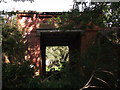
4
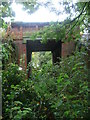
Old bridge under the railway near Tiepigs Lane
This bridge is immediately to the west of the bridge in Tiepigs Lane, just before the terminus of the line is reached at Hayes. I am not sure of its original purpose and it is very overgrown now. The Hayes branch line from the Mid-Kent line at Elmers End was built by the West Wickham & Hayes Railway, but was sold to the South Eastern Railway on the opening day, 29th May 1882. This area saw urbanisation relatively late and usage of the line remained low until electrification in 1925.
Image: © Marathon
Taken: 21 Oct 2012
0.13 miles
5
Tiepigs Lane, Hayes
The railway bridge is also the boundary with West Wickham
Image: © David Howard
Taken: 29 Dec 2013
0.13 miles
6
Another arch of Trepigs Lane railway Bridge
As seen from a footpath from Trepigs Lane to Pickhurst Rise.
This arch is about 40 yards left of Image
Image: © David Anstiss
Taken: 28 Aug 2011
0.14 miles
7
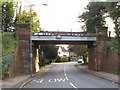
Railway bridge near Hayes
A railway bridge across Tiepigs Lane, near Hayes in the outer suburbs of south east London. A warning sign on the bridge indicates a height limit of 14 feet and 6 inches.
The railway which crosses this bridge is a suburban branch line which reaches a terminus at Hayes.
Image: © Malc McDonald
Taken: 27 Oct 2019
0.14 miles
8
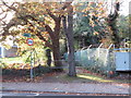
Public footpath near Hayes
A public footpath in the outer suburbs of south east London. To the right of the path is a railway embankment.
Image: © Malc McDonald
Taken: 27 Oct 2019
0.14 miles
9
Tiepigs Bridge
The view of the railway bridge over Tiepigs Lane near Hayes Railway Station.
Image: © Gordon Griffiths
Taken: 15 Nov 2016
0.15 miles
10
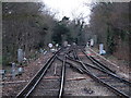
Railway lines west of Hayes (Kent) station
Image: © Mike Quinn
Taken: 11 Jan 2011
0.15 miles