IMAGES TAKEN NEAR TO
Kemsing Close, BROMLEY, BR2 7ET
Introduction
This page details the photographs taken nearby to Kemsing Close, BR2 7ET by members of the Geograph project.
The Geograph project started in 2005 with the aim of publishing, organising and preserving representative images for every square kilometre of Great Britain, Ireland and the Isle of Man.

There are currently over 7.5m images from over14,400 individuals and you can help contribute to the project by visiting https://www.geograph.org.uk
Image Map
Images are licensed for reuse under creativecommons.org/licenses/by-sa/2.0
Notes
- Clicking on the map will re-center to the selected point.
- The higher the marker number, the further away the image location is from the centre of the postcode.
Image Listing (129 Images Found)
Images are licensed for reuse under creativecommons.org/licenses/by-sa/2.0
Image
Details
Distance
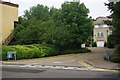
1
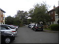
Kemsing Close, Hayes
Looking towards Bourne Way from the end of this short cul de sac.
Image: © Richard Vince
Taken: 28 Sep 2019
0.01 miles
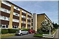
3
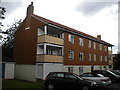
Low rise flats on Kemsing Close, Hayes
Image: © Richard Vince
Taken: 28 Sep 2019
0.02 miles
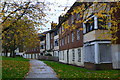
5
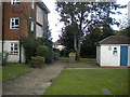
Footpath off Kemsing Close, Hayes
Providing access to some low rise flats.
Image: © Richard Vince
Taken: 28 Sep 2019
0.03 miles
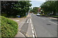
6
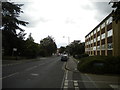
Bourne Way, Hayes
Looking towards Coney Hall from the junction with Saville Row.
Image: © Richard Vince
Taken: 28 Sep 2019
0.03 miles
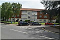
10
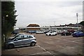
Hayes Station Car Park
I am sure a combination of sky rocketing parking fees and summer holidays are the reason there are so many spare spaces on a working day.
Image: © Glyn Baker
Taken: 21 Aug 2012
0.06 miles