IMAGES TAKEN NEAR TO
Holland Way, BROMLEY, BR2 7DW
Introduction
This page details the photographs taken nearby to Holland Way, BR2 7DW by members of the Geograph project.
The Geograph project started in 2005 with the aim of publishing, organising and preserving representative images for every square kilometre of Great Britain, Ireland and the Isle of Man.

There are currently over 7.5m images from over14,400 individuals and you can help contribute to the project by visiting https://www.geograph.org.uk
Image Map
Images are licensed for reuse under creativecommons.org/licenses/by-sa/2.0
Notes
- Clicking on the map will re-center to the selected point.
- The higher the marker number, the further away the image location is from the centre of the postcode.
Image Listing (120 Images Found)
Images are licensed for reuse under creativecommons.org/licenses/by-sa/2.0
Image
Details
Distance
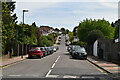
1
Sandiland Crescent, Hayes (Kent)
Taken from Holland Way.
Image: © David Kemp
Taken: 7 Mar 2015
0.07 miles
2
Modern Times on the London Loop
The road sign on the right informs drivers with their brains turned off that their "sat nav" is sending them up a blind alley. It is a no through road sign with the text "Sat Nav Error" below. The fact the road is a public byway open to all traffic does not mean the council can't put bollards at one end to prevent through traffic. The clue is in the name "Warren Wood Close". The byway is part of the London Loop https://www.ldwa.org.uk/ldp/members/show_path.php?path_name=London+Loop path.
Image: © Glyn Baker
Taken: 31 Aug 2016
0.10 miles
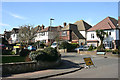
3
Sandiland Crescent, Hayes
This is Sandiland Crescent, not far from Hayes station. A small green at the bend in the road shows that Warren Wood is an 'Area of Special Landscape Character'.
Image: © Marathon
Taken: 9 Oct 2013
0.10 miles
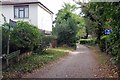
4
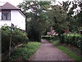
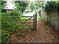
London Loop Link on Warren Wood Close
This byway between Holland Way and Warren Road, is used by a link way for the long distance path leading towards Hayes Railway Station (from the path in Hayes Common).
In the background on the right is Warren Cottage.
Image: © David Anstiss
Taken: 28 Aug 2011
0.10 miles
5
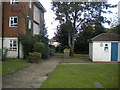
Footpath off Kemsing Close, Hayes
Providing access to some low rise flats.
Image: © Richard Vince
Taken: 28 Sep 2019
0.11 miles
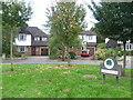
6
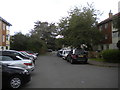
Kemsing Close, Hayes
Looking towards Bourne Way from the end of this short cul de sac.
Image: © Richard Vince
Taken: 28 Sep 2019
0.11 miles
7
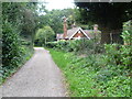
London LOOP link to Hayes station at Warren Wood Close
The London LOOP is a 150 mile signed walk around the edge of Outer London, England, described as "the M25 for walkers". Here the path is on the edge of Hayes Common forming a link to Hayes station a little way ahead. In the other direction it joins up with the LOOP proper between Keston and West Wickham. The building on the right appears to be a former lodge with the woodland of Hayes Common behind it.
Image: © Marathon
Taken: 9 Oct 2013
0.11 miles
8
London LOOP link to Hayes station at Warren Wood Close
The London LOOP is a 150 mile signed walk around the edge of Outer London, England, described as "the M25 for walkers". Here the path is on the edge of Hayes Common forming a link to Hayes station. In a while it joins up ahead with the LOOP proper between Keston and West Wickham.
Image: © Marathon
Taken: 9 Oct 2013
0.11 miles
9
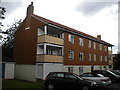
Low rise flats on Kemsing Close, Hayes
Image: © Richard Vince
Taken: 28 Sep 2019
0.11 miles