IMAGES TAKEN NEAR TO
Ridgeway, BROMLEY, BR2 7DF
Introduction
This page details the photographs taken nearby to Ridgeway, BR2 7DF by members of the Geograph project.
The Geograph project started in 2005 with the aim of publishing, organising and preserving representative images for every square kilometre of Great Britain, Ireland and the Isle of Man.

There are currently over 7.5m images from over14,400 individuals and you can help contribute to the project by visiting https://www.geograph.org.uk
Image Map
Images are licensed for reuse under creativecommons.org/licenses/by-sa/2.0
Notes
- Clicking on the map will re-center to the selected point.
- The higher the marker number, the further away the image location is from the centre of the postcode.
Image Listing (172 Images Found)
Images are licensed for reuse under creativecommons.org/licenses/by-sa/2.0
Image
Details
Distance
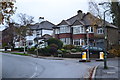
3
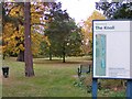
The Knoll
The view of the park off the Ridgeway in Hayes, Bromley.
Image: © Gordon Griffiths
Taken: 23 Oct 2015
0.04 miles
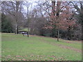
5
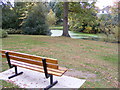
Knoll Bench
The view of the park off the Ridgeway in Hayes, Bromley.
Image: © Gordon Griffiths
Taken: 23 Oct 2015
0.05 miles
9
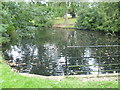
Pond in The Knoll, Hayes
The park known as The Knoll at Hayes features a series of ponds with a further pond to the north of Pickhurst Lane in Husseywell Open Space. This is the southernmost of the ponds.
Image: © Marathon
Taken: 9 Oct 2013
0.07 miles
10
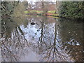
Pond, Hayes Recreation Gardens (8)
The water from this pond must flow northwards into the River Ravensbourne - Hayes Branch - see Image
Image: © Mike Quinn
Taken: 11 Jan 2011
0.07 miles