IMAGES TAKEN NEAR TO
Baston Road, BROMLEY, BR2 7BE
Introduction
This page details the photographs taken nearby to Baston Road, BR2 7BE by members of the Geograph project.
The Geograph project started in 2005 with the aim of publishing, organising and preserving representative images for every square kilometre of Great Britain, Ireland and the Isle of Man.

There are currently over 7.5m images from over14,400 individuals and you can help contribute to the project by visiting https://www.geograph.org.uk
Image Map
Images are licensed for reuse under creativecommons.org/licenses/by-sa/2.0
Notes
- Clicking on the map will re-center to the selected point.
- The higher the marker number, the further away the image location is from the centre of the postcode.
Image Listing (75 Images Found)
Images are licensed for reuse under creativecommons.org/licenses/by-sa/2.0
Image
Details
Distance
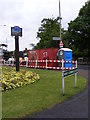
1
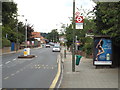
Baston Road, Hayes
A Transport for London (TfL) bus stop on Baston Road in Hayes.
Image: © Malc McDonald
Taken: 31 Jul 2016
0.05 miles
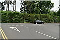
3
Looking south-southwest along West Common Road
Image: © Basher Eyre
Taken: 30 Jun 2012
0.11 miles
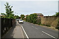
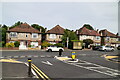
4
West Common Road
A Road in Hayes, Kent.
Image: © Gordon Griffiths
Taken: 26 May 2009
0.12 miles
7
Hayes Convenience
A road works portaloo on the corner of West Common Road and Hayes Street, Kent.
Image: © Gordon Griffiths
Taken: 26 May 2009
0.13 miles
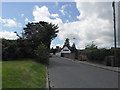
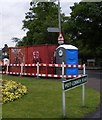
8
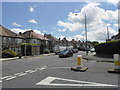
Junction of West Common Road and Baston Road
Image: © Basher Eyre
Taken: 30 Jun 2012
0.13 miles