IMAGES TAKEN NEAR TO
Milking Lane, KESTON, BR2 6DD
Introduction
This page details the photographs taken nearby to Milking Lane, BR2 6DD by members of the Geograph project.
The Geograph project started in 2005 with the aim of publishing, organising and preserving representative images for every square kilometre of Great Britain, Ireland and the Isle of Man.

There are currently over 7.5m images from over14,400 individuals and you can help contribute to the project by visiting https://www.geograph.org.uk
Image Map
Images are licensed for reuse under creativecommons.org/licenses/by-sa/2.0
Notes
- Clicking on the map will re-center to the selected point.
- The higher the marker number, the further away the image location is from the centre of the postcode.
Image Listing (45 Images Found)
Images are licensed for reuse under creativecommons.org/licenses/by-sa/2.0
Image
Details
Distance
1
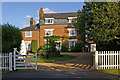
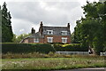
Old House Farmhouse
The front section of this grade II listed house dates from the 18th century, with the rear possibly older. It is mentioned in Edward Hasted's "The History and Topographical Survey of the County of Kent" of 1797 as having been "for many generations, and till lately, the residence of the Braziers", which supports the suggestion that the building goes back further. For listing particulars, see www.historicengland.org.uk/listing/the-list/list-entry/1064392.
Image: © Ian Capper
Taken: 30 Jul 2009
0.01 miles
2
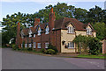
Old Farm Cottage and Greensleeves Cottage
Originally dating from the 17th century, this building, split into two cottages, is grade II listed. For listing particulars see www.historicengland.org.uk/listing/the-list/list-entry/1354760. The gate in the left background gives emergency access to Biggin Hill Airfield.
Image: © Ian Capper
Taken: 30 Jul 2009
0.03 miles
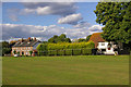
4
Leaves Green
This is Dove Cottage, with an unusual floral motif on the front.
Image: © Ian Capper
Taken: 30 Jul 2009
0.04 miles
6
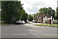
Leaves Green
On the left is the former Cudham Workhouse (see Image) and on the right is Dove Cottage (see Image).
Image: © Ian Capper
Taken: 30 Jul 2009
0.05 miles
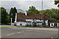
7
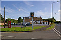
The King's Arms
At the junction of Leaves Green Road, this grade II listed pub has stood here since at least the 18th century. For listing particulars, see www.historicengland.org.uk/listing/the-list/list-entry/1064393. The pub is very popular during the annual Biggin Hill Airshow, as its large garden backs onto the Airfield.
The phone box, of Giles Gilbert Scott's K6 design, is also grade II listed.
Image: © Ian Capper
Taken: 30 Jul 2009
0.05 miles
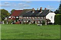
10
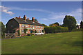
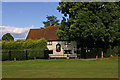
Cudham Workhouse
Despite the name, this would no longer be considered to be in Cudham but in nearby Leaves Green. It was built in 1731 and divided into 3 cottages (Ramblers Rest, Workhouse and Jasmine) some time in the early 20th century. Rambler's Rest once served as a café. The building is grade II listed - for listing particulars see www.historicengland.org.uk/listing/the-list/list-entry/1055773.
For close up of plaque on the front of the building, see Image
Image: © Ian Capper
Taken: 30 Jul 2009
0.06 miles